A comprehensive guide to understanding Earth's crusts
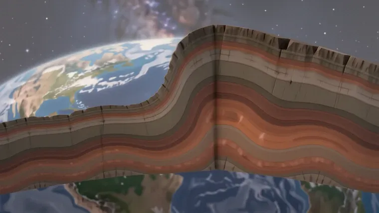
The Earth’s crust consists of two distinct types of lithospheric material: thin, dense oceanic crust and thick, buoyant continental crust. While the average thickness of this solid outer shell measures 35-40 km, specific regions vary significantly because tectonic processes constantly redistribute mass and heat. Oceanic crust typically reaches depths of only 5-10 km, whereas continental crust can exceed 70 km in mountainous regions like the Himalayas.
Composition and Chemical Structure
The crust contains diverse minerals. It is a complex mixture. Eight chemical elements constitute 99% of the total mass because oxygen, silicon, aluminum, iron, calcium, sodium, potassium, and magnesium dominate the chemical landscape. These elements combine into approximately 6,000 known mineral species. Most are rare.
Density varies by location. The oceanic crust is heavy. It consists primarily of basalt, which contains high concentrations of iron and magnesium silicates so that it remains denser than the continental material above it. This density difference drives subduction.
The continental crust is lighter. It holds more silica. Sedimentary and granite layers define much of the landmass because these rocks form through different cooling and depositional histories over billions of years. Some mountain rocks date back 3.5 billion years.
Geologists use seismic waves. They measure speed. Because the velocity of a wave changes when it hits a new material, scientists can map the internal layers without drilling deep into the mantle. This method relies on elasticity.
The Kola Peninsula borehole provides data. It reached 12.26 kilometers in 1989. Even this extreme depth failed to penetrate the basalt layer because the immense pressure and temperature made further drilling technically impossible for the researchers involved.
The Lithosphere and Tectonic Plates
The lithosphere is solid. It moves slowly. This layer includes the crust and the uppermost portion of the mantle, although it behaves as a rigid unit that floats atop the more plastic asthenosphere. Movement is constant.
Plates shift annually. Rates vary widely. Most plates move between 1 and 6 cm per year, while the East Pacific Ridge near Easter Island moves at 18 cm per year because of rapid seafloor spreading. Some areas are slow.
The Mid-Atlantic Ridge shows variation. The northern section slides at 2.3 cm per year. In contrast, the southern section reaches 4 cm per year because the thermal driving forces differ across the ridge’s length.
Subduction consumes crust. One plate sinks. When an oceanic plate meets a continental plate, the thinner oceanic slab descends into the mantle so that the denser material can be recycled into the Earth’s interior. This process creates trenches.
The Nazca Plate is active. It collides with South America. This specific interaction forces the seafloor downward because the oceanic crust is significantly more dense than the surrounding continental lithosphere.
Collision builds mountains. No plate yields. When the Indian plate collided with the Eurasian plate, the crust buckled upward to form the Himalayas after neither side could be easily subducted into the mantle.
Mantle Dynamics and Heat Transfer
The mantle is thick. It is massive. This layer extends 2,890 km deep and contains 69% of the planet’s total mass because silicate rocks make up its primary composition. It is not liquid.
Convection drives motion. Heat rises upward. Large-scale convective cells move material from the mantle to the surface because the high temperatures cause the silicate rocks to become pliable and mobile. This creates faults.
The pressure is immense. It reaches 140 GPa. Lower mantle pressures are extreme so that the mineral structures undergo phase transitions which change how seismic waves travel through the deep interior.
Hotspots create islands. Mantle plumes rise. These columns of hot material originate near the core-mantle boundary and ascend toward the surface because they possess higher thermal energy than the surrounding mantle. Hawaii formed this way.
The D” layer exists. It is deep. This layer sits approximately 200 km above the core-mantle boundary, although its exact thickness and chemical properties remain subjects of intense geophysical debate.
The Core and Magnetic Generation
The core is central. It is hot. The outer core remains liquid from 2,900 km to 5,100 km deep because temperatures reach between 5,000 and 6,000 degrees Celsius. This layer flows.
Convection generates fields. Iron moves constantly. The movement of molten iron in the outer core creates the Earth’s magnetic field so that the planet is protected from solar radiation. It is a dynamo.
The inner core is solid. It is dense. High pressures prevent the center from melting even though temperatures are extreme because the weight of the entire planet compresses the iron-nickel alloy into a solid state.
The radius is 3,486 km. It is heavy. The core accounts for 31% of the Earth’s mass despite occupying only 16% of its total volume.
Geological Forces and Relief
Internal forces shape land. They move rocks. Energy from the core causes seismic activity and volcanic eruptions because the accumulation of stress eventually reaches a breaking point in the crust. Earthquakes follow.
External forces erode. The sun provides energy. Wind and water reshape the surface after temperature variations and precipitation break down solid rock into smaller sediments over long periods. This creates valleys.
Plains are vast. They are flat. Lowland plains like the Amazon or the West Siberian Plain feature minimal elevation changes because they lack the tectonic uplift found in mountain belts.
Mountains rise high. They erode fast. Once internal forces push a range upward, external processes immediately begin to wear down the peaks so that the relief eventually stabilizes. The Urals show this.
Relief can be convex. It can be concave. Mountains and ridges form convex shapes, while river valleys and basins create concave depressions in the landscape.
Oceanic topography is complex. Ridges exist deep. Mid-ocean ridges act as underwater mountain ranges where new crust forms because magma rises to fill the gaps between separating plates.
Measuring the Crust
GPS technology is precise. It tracks movement. Modern receivers measure plate shifts with accuracy down to a fraction of a millimeter per year because satellite positioning provides a stable reference frame.
Seismic waves reveal layers. They travel fast. Sedimentary rocks transmit waves at 3 km/s, while granite transmits them at 5 km/s after the waves pass through different mineral densities. This allows mapping.
The Moho discontinuity is clear. It sits at 50 km. This boundary separates the crust from the mantle because there is a significant change in seismic velocity at this depth.
Human activity changes things. We move earth. Mining and construction alter the surface, although these changes are much smaller in scale than the massive movements of tectonic plates.
The Earth remains mysterious. We have barely scratched it. Our deepest boreholes reach only 12 km, which is a tiny fraction of the 6,371 km radius because the heat becomes too intense for our current tools.
Frequently asked questions
What is the difference between oceanic and continental crust?
Oceanic crust is thin (5-10 km) and dense, primarily composed of basalt. Continental crust is thicker, often exceeding 70 km in mountains, and is lighter due to higher silica content.
How fast do tectonic plates move?
Most plates move between 1 and 6 cm per year. However, some areas like the East Pacific Ridge move much faster, at approximately 18 cm per year.
What causes the Earth's magnetic field?
The magnetic field is generated by a dynamo effect caused by the movement of molten iron in the liquid outer core, which extends from 2,900 km to 5,100 km deep.
How do scientists map the Earth's internal layers?
Geologists use seismic waves to map the interior. Because wave velocity changes when hitting different materials, scientists can identify layers without drilling deep into the mantle.
More in Solar System
Calculating the Earth's mass: A complex task
Learn how scientists use the gravitational constant and orbital mechanics to determine Earth's mass of approximately 5.9722 x 10^24 kg.
Discovering the current location of Voyager in interstellar space
Learn about the current location of Voyager 1 and 2, their distances from Earth, and how they navigate the harsh environment of interstellar space.
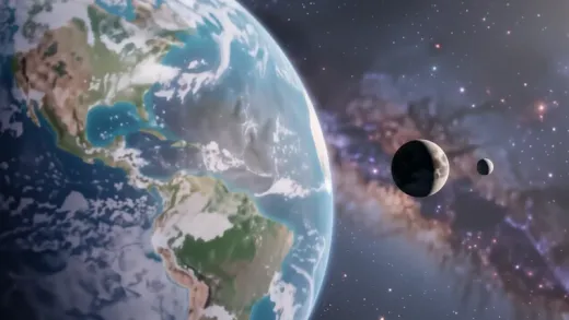
How many natural satellites does the earth possess?
Explore Earth's celestial companions, from the permanent Moon to transient quasi-satellites and cosmic dust clouds located at Lagrange points.
How many planets orbit the sun in second grade lessons
Learn how many planets orbit the sun and discover key facts about the eight official planets, from Mercury to Neptune, for students and educators.