When embarking on a sea voyage, the fear of losing one’s way is a thing of the past. Thanks to cutting-edge technology such as GPS navigators, radar systems, and meticulously crafted maps, sailors can navigate through the vast ocean with ease. However, it is worth noting that throughout most of human history, mariners relied solely on the celestial bodies to guide them on their journeys. This ancient practice, known as astronomical navigation, may no longer be as prevalent in modern times, but its accuracy remains unparalleled. While modern advancements have made navigation more accessible, possessing the knowledge of star chart reading ensures that one can confidently traverse great distances from the safety of the shore.
Acquiring expertise in the field of celestial navigation is no simple task, but it can prove to be immensely valuable during emergencies. This is where its primary benefit lies: there is no need for maps or electronic devices, as all the necessary knowledge resides within your own mind. However, the one limitation is that this knowledge can only be applied when the stars or the sun are visible in the sky.
Within our brief article, we have provided only the fundamental principles of celestial navigation. For a more comprehensive understanding of this subject, we recommend consulting additional tutorials and guides.
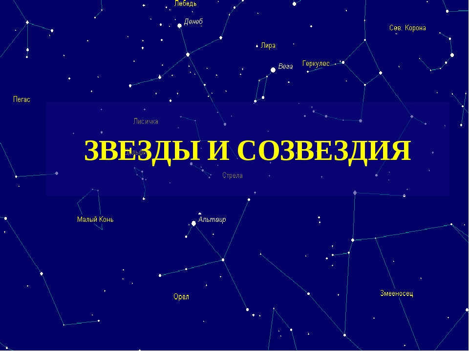
Astronomical navigation: the fundamentals
Astronomical navigation involves determining your precise location by considering two crucial factors: the precise position of the star or celestial body that the observer is focused on, and the angle between the horizon and that celestial body. By connecting these points, a kind of triangle is formed. To perform these calculations, you will need certain tools, knowledge, and an adequate amount of time.
- A sextant, which is an instrument designed for measuring angles;
- A clock;
- An up-to-date nautical astronomical almanac.
Calculating your location
First, you need to determine your position at a specific time. The Nautical Astronomical Almanac provides a list of over 50 stars, as well as the Moon and Sun, that can be used for orientation. If you plan on stargazing (which is the process of determining the position of a star), make sure that the horizon line and stars are highly visible.
Next, after locating the celestial body that you will be using for your calculations, use a sextant to measure the angle between yourself and the celestial body. Remember to record the exact time (Greenwich Mean Time – GMT) when taking the measurement.
Step 3: Once you have completed this task, you will need to make adjustments to your measurements based on factors such as the height above the horizon line. To do this, you will require a special guide, which it is advisable to prepare in advance and keep on board the boat at all times. After making these corrections and refinements, you will be able to determine the observed altitude of the celestial body.
Step 4: Next, consult the Nautical Astronomical Almanac. Within this resource, you will find the necessary data for the chosen celestial navigation point, including the calculated altitude of the celestial body in relation to your current location. If your own calculations do not fall within this range, you will need to adjust your position accordingly.
Step 5: Finally, utilize the local hour angle value, along with the estimated latitude and declination of the celestial body, to make further adjustments. This additional information can also be found in the almanac.
This guide provides a brief overview of the topic. If you are interested in becoming an expert in astronomical navigation, you have the option to enroll in specialized courses. Mastering this knowledge requires time and effort, but it is truly a remarkable achievement of human civilization and progress.
I will attempt to explain the process of orienting yourself in the sky and locating specific constellations and planets in the simplest way possible. Nowadays, with the availability of online maps, this task has become quite straightforward.
First and foremost, it is important to familiarize yourself with the surrounding terrain and determine the cardinal directions – North (N), South (S), West (W), and East (E). Once you know the direction of at least one side, determining the others becomes elementary, as they are positioned as follows:
You are currently located in the central area. To help you navigate, you can make use of a regular compass.
In simpler terms, this is a lesson on geography for third graders.
Click on the link provided and enter the initial details of the location and time for observation:
1. “Time (UT)” – the universal time of your observation (to calculate it, subtract the time difference with the universal time from your current time. For instance, for Moscow: in winter -3 hours, in summer -4. So, if it’s 12:45 on my watch now, according to UT, it is 9:45).
2. “Date” simply represents the date of the observation.
3. “City” – your city. If your city is not available, choose the nearest one from the list – the difference will not affect the result.
4. “Part of the sky” – select “All sky”.
Do not modify anything else and click “Go!”. The map will load, which can be printed or viewed from the monitor.
Thirdly, we can use the obtained map to navigate ourselves among celestial objects. To do this, we hold the map above our heads and align it with the cardinal directions. The map uses Latin letters N for North, S for South, E for East, and W for West.
Now the map accurately represents what we see in the actual sky. Keep in mind that the map includes more stars than what is visible to the naked eye. The naked eye can only see the brightest stars, which have a high “stellar magnitude” rating (1 being the brightest and 6 being faint and almost invisible).
The map also indicates the positions of planets and the Moon. With this information, it will be much easier to locate bright stars and planets.
Undoubtedly, words hold great significance, but rest assured that this procedure will only consume a few minutes of your time. As you gain experience, you will find that there is no need to rely solely on the map to locate the most dazzling stars and constellations.
If any aspect of the process seems unclear, don’t hesitate to ask for clarification. We will work together to find a solution!
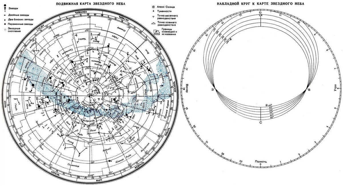
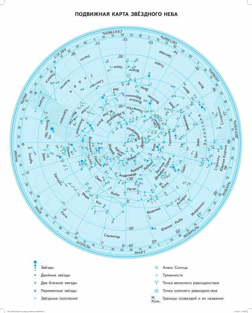
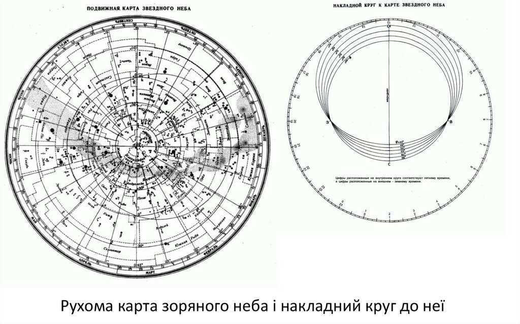
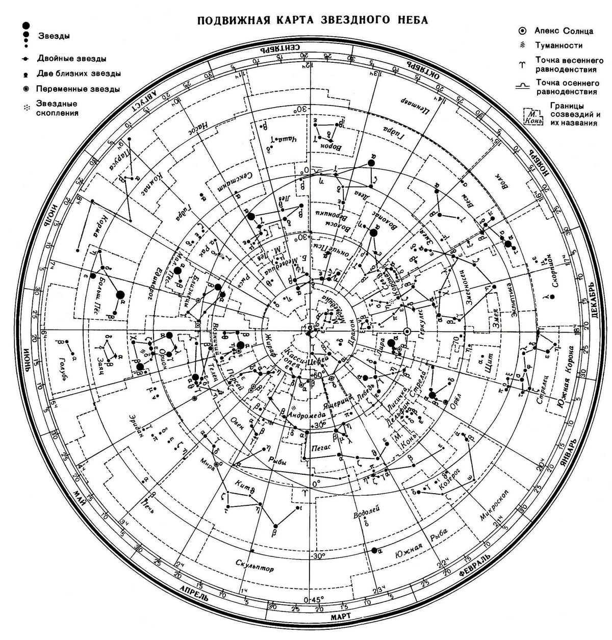
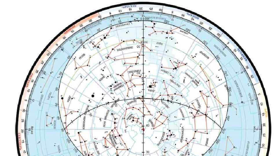
An astronomical star map, whether large or small, is a portable cartographic representation. It allows for precise determination of the positions of celestial bodies at specific times.
Such educational tools were employed in ancient times, when individuals first began to comprehend the perpetual motion of astronomical objects.
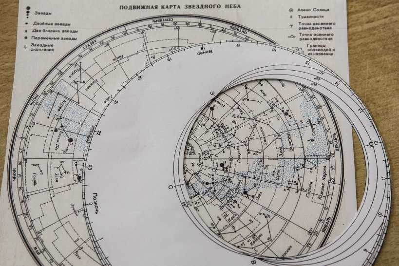
The educational kit consists of a movable map of the starry sky and an overlapping circle attached on top. Each part is marked with specific information: the map has calendar dates on its surface, while the circle has time markings along its perimeter.
By gradually rotating the circle, the two perimeters are connected, creating a slice of the starry sky that is optimally visible. This allows for the observation of current astronomical bodies within a specific zone on the overlapping circle.
The movable sky map is designed to help identify constellations and basic astronomical objects based on several parameters:
- Calendar date
- Geographic latitude of the current location
- Current time of observation of astronomical objects
It is important to mention that the visible starry sky map does not indicate the specific year. It can be confirmed that even two centuries ago, the sky remained unchanged and the celestial bodies were in similar positions.
There are customizable starry sky maps designed specifically for the latitudes of Russian cities. This allows students to observe in their astronomy lessons the constellations, cosmic objects, and phenomena that are present in their specific zone.
Each astronomy kit for the school’s astronomy club is certified in accordance with the requirements of the Federal State Educational Standards, making it suitable for use within the general educational process.
How to utilize the mobile map of the celestial sky?
In order to ascertain the location of astronomical entities, it is imperative to prepare a specialized map of the starry sky. One can either employ a pre-made version or print it out on paper based on the provided template. Additionally, a circular cutout with a designated aperture, conforming to the latitude of the observation area, should be carefully detached.
The process of operating a moveable star map is quite straightforward. Initially, one must superimpose the circle on top in a manner that aligns the current date on the paper overlay with the corresponding time on the circular cutout. Instantaneously, the stars and constellations that are currently positioned above the celestial dome will become visible within the encircled protrusion.
It is crucial to keep in mind that the inner digits on the dial on the surface of the overlay circle replicate daylight saving time, while the outer digits replicate standard time. For added convenience, it is advisable to pull the strings on the surface circle in a southern direction from the north. This technique allows for determining a halfway point, slightly closer to the north, by tying a knot.
Upon venturing beneath the sky, a properly calibrated celestial map should be positioned above the head, aligning correctly with all sides of the world duplicated on the surface circle. The center point, known as the zenith, serves as a reference for projecting various celestial bodies downward in different directions.
We will gather all the necessary equipment and furniture, prepare the required documents, and deliver them with a delay of 45 days.
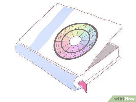
Are you interested in learning how to create your own natal chart? Would you like to discover insights and gain clarity on your life path? Making a natal chart can provide valuable self-understanding and guidance. Our team of experienced astrologers has compiled a comprehensive guide on how to create and interpret your own natal chart.

In order to comprehend the complexities of the celestial expanse, we sought guidance from the esteemed instructor at Konstantin Daragan’s online school, the ever-knowledgeable astrologer-forecaster Daria Sibiryakova, as well as the insightful astrologer Albina.
Within this article, we shall delve into the following topics:

What is the purpose of a natal chart and why create one?

This chart provides insights into your personality, revealing both strengths and weaknesses, as well as behavioral patterns, psychological traits, and talents. By understanding these aspects, you can avoid making fatal mistakes and encountering unnecessary troubles, while also guiding your personal development in the right direction.
The natal chart holds the key to unlocking the secrets of your future, as it encompasses all the significant events and influences in your life.
A natal chart can provide answers to various questions, such as: What will my career be like? How many children will I have? Which field will I find my true calling in?
To calculate your natal chart, you simply need to know your birth date, place, and exact time.
You can easily generate your own natal chart without having to manually calculate or draw anything! The internet offers a wide range of online astro-processors that can automatically generate a natal chart based on the provided parameters.

In order to obtain your individual horoscope, the software will prompt you to enter your name, gender, date, location, and precise time of birth down to the minute. It is important to avoid making any mistakes, as the accuracy of the natal chart will depend on it.
Take a look at what the generated natal chart layout will resemble:
The task at hand is both challenging and captivating – interpreting the natal chart. It is feasible to accomplish this task independently. However, if you aspire to delve deeper into the realm of astrology, taking courses becomes indispensable.

Understanding the natal chart
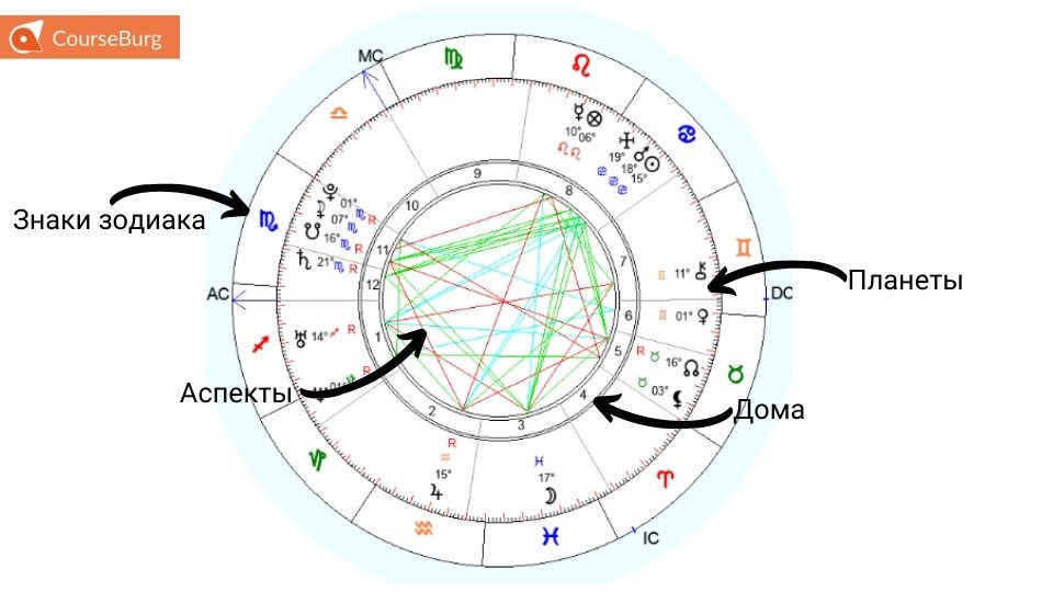
Deciphering a natal chart involves understanding the significance of the four fundamental components: the zodiac signs, planets, houses, and aspects.
Let’s grasp the significance of the fundamental principles in order to accurately decipher the natal chart.
Components of the natal chart
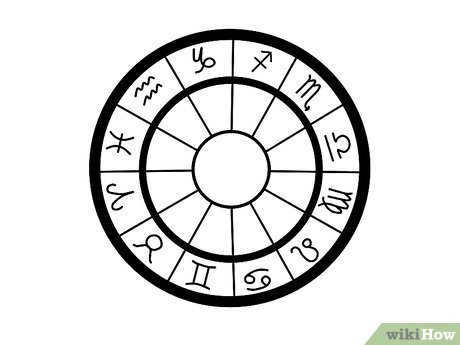
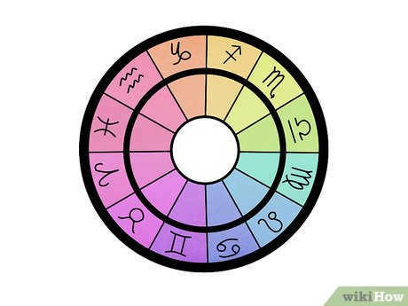
The natal chart encompasses 12 zodiac signs, 12 houses, and 10 planets. It is vital for us to comprehend their meanings and how they interact with one another.
Zodiac Signs
Each zodiac sign possesses a unique energy that is expressed through various elements such as houses, planets, and aspects.

Each astrological sign possesses its own unique set of characteristics:
- Aries – vigor, determination, assertiveness, impulsive action.
- Taurus – practicality, aversion to change, self-reliance.
- Gemini – adaptability, curiosity, love of knowledge, need for communication.
- Cancer – nurturing, domesticity, strong intuition, introspection.
- Leo – radiance, self-expression, creativity.
- Virgo – rationality, attentiveness, diligence, punctuality.
- Libra – partnership, tranquility, desire for equilibrium.
- Scorpio – guardianship, receiving rewards.
- Capricorn – responsibility, planning, self-control.
- Aquarius – sociality, ease of communication, love of change.
- Pisces – sensitivity, inner harmony.
Houses represent different areas of life and circumstances.
When a planet enters a specific house, it expresses its energy through the sphere of that house.
In other words, the planet’s energy will be channeled into the areas of life that are influenced by the house.
The zodiac signs associated with the house describe the nature of the actions that will take place.
- The first house – a person’s personality, character, demeanor, and behavior.
- The second house – finances, property, acquisitions, spending, and resource replenishment.
- The third house represents communication, the immediate environment, the exchange of information, and self-expression through words.
- The fourth house is associated with family, home, inheritance, and the past.
- In the fifth house, we find children, love, recreation, and entertainment.
- The sixth house pertains to work, responsibility, and duties.
- The seventh house deals with unions, partnerships, and marriage.
- When it comes to the eighth house, we encounter danger, extremes, and other people’s money.
- The ninth house is connected to travel, higher education, and professionalism.
- The tenth house is all about status, social position, career, and the realization of one’s personality.
- In the eleventh house, we explore dreams, aspirations, hopes, and plans.
- The twelfth house encompasses secrets, mysteries, deceptions, religion, and everything subconscious.
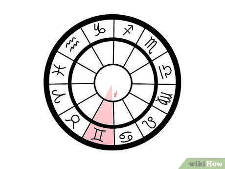
For instance, the image illustrates the 2nd dwelling in Taurus: this astrological sign is known for its practical nature, aversion to change, and the 2nd residence governs matters of finance and expenditure. By assessing these attributes, one can deduce that the individual is likely a diligent materialist. They have a distaste for spending, opting instead to save and amass wealth.

Celestial Bodies
Celestial bodies depicted in the birth chart provide insights into an individual’s character traits and their purpose in life.
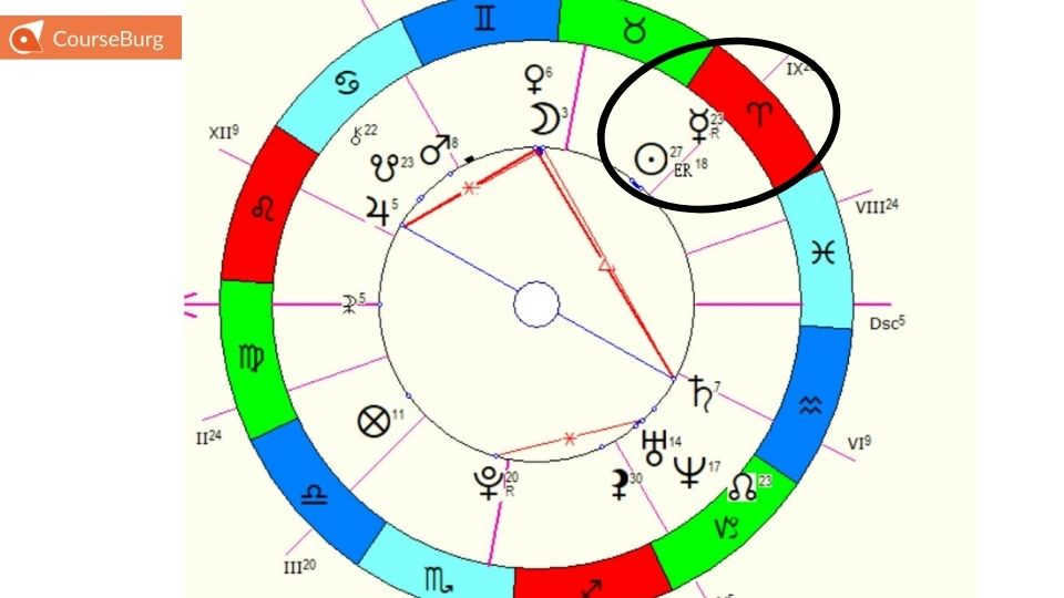
In this birth chart, the Sun is positioned in Aries. The individual is likely to possess a high level of activity, energy, and dedication. They also have a natural charisma and leadership abilities.
- The Moon represents the subconscious mind, self-determination, and instincts.
- Mars symbolizes action, strength, activity, and initiative. It brings a competitive spirit and a slightly assertive nature.
- Mercury represents communication abilities and information processing. It is responsible for learning, communication, and the surrounding environment.
- Venus is responsible for love, relationships with the opposite sex, desire, and sensuality. It encompasses everything that brings pleasure and enjoyment.
- Saturn represents discipline, limitations, responsibility, and spiritual growth through overcoming challenges. It symbolizes the later stages of life when one reaps the rewards of their years lived.
- Uranus represents change, unconventional thinking, and ingenuity. It is the patron planet of scientific progress and scientists.
- Neptune is associated with imagination and the spiritual realm. It is responsible for fantasies and phobias and is always tied to something mystical and unexplainable.
- Pluto represents intuition, unconscious reactions, and potent energy. It is associated with all that is hidden and secretive.
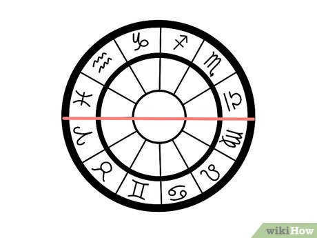
The connections between the planets are known as aspects. Aspects can be harmonious, indicating opportunities or positive qualities, or tense, bringing problems and obstacles.
In essence, planets reveal what is expected to occur, signs indicate how it will occur, and houses signify which area of life will be impacted.
For instance, if Venus is positioned in the fourth house, it suggests a love for family, children, and a strong emotional bond with the home, as well as favorable conditions for receiving an inheritance. On the other hand, if Jupiter is located in the fourth house, it signifies opportunities to purchase a comfortable home.
For novice learners, comprehending the interplay between the various components of an astrology chart and integrating them into a cohesive whole can be challenging. It is advisable to begin with a simple approach: understanding the placements of planets in houses and signs, and grasping the implications of these combinations.
Are you already eager to delve into the realm of astrology and uncover all there is to know about yourself?
There are a couple of choices available. The initial one is to attempt comprehending everything independently by utilizing books and the Internet. The second alternative is significantly simpler and more efficient – to receive guidance from an astrologer.

We have compiled a list of 4 helpful tips to assist you in selecting an astrology course that is worth your investment.
- It is crucial for the course to cover the fundamentals of astrology, such as planets, signs, and houses. Without a solid understanding of these basics, it will be difficult to progress in your studies.
- If the school offers free lessons, take advantage of them. This will enable you to assess whether the teacher’s teaching style and language are suitable for you.
- Ensure that the course includes practical exercises. Look for schools that incorporate homework assignments with feedback from the teacher.
- Be cautious of schools that claim to turn you into an astrologer overnight. Astrology is a complex field, and it’s unrealistic to expect to grasp the intricacies of this ancient practice in just a few weeks or even a month.
The price range for astrology courses varies from 8,000 rubles to 35,000 rubles.
Upon completion of the course, many schools provide a certificate to acknowledge your successful completion of the program. This certificate can help you turn astrology into a source of income rather than just a hobby. The fees for consultations with beginner astrologers usually range from 1,500 to 2,000 rubles, while experienced astrologers may charge anywhere from 15,000 to 20,000 rubles for their services.
This course might be suitable for you:
- Top 10 Tarot Training Courses Available Online
- Best Online Astrology Classes
- Explore the 10 Best Online Tarot Card Courses starting from 2,500 Rubles
- Discover the Top 10 Psychology Courses in St. Petersburg
Share your thoughts in the comments – do you believe in astrology? Be sure to repost so you won’t forget how to create and interpret a natal chart!
wikiHow follows the collaborative wiki approach, which means that many of our articles are written by multiple authors. At the time this article was created, 37 individuals contributed to its editing and improvement, some of whom chose to remain anonymous.
An astrological chart, also known as a natal chart, is a symbolic representation of the positions of the planets, Sun, and Moon at the moment of an individual’s birth. Each planet is located in a specific zodiac sign at a specific time, and by interpreting this arrangement, astrologers can gain insights into unique aspects of human behavior. While an astrological chart is grounded in factual data, such as the precise positions of celestial bodies in relation to the Moon during a specific time period, it is more closely aligned with astronomy rather than astrology. The following guidelines will assist you in creating your own astrological chart.

- Alternatively, you have the option of obtaining empty astrology templates from an astrologist or an astrology shop. It is simpler to manually sketch the circles.
To create an astrological chart, you need to divide the space between the two outer circles into 12 equal parts. Each of these parts represents one of the 12 zodiac signs, such as Cancer, Libra, and others.
- When you have knowledge of the exact time you were born, you can determine your ascendant (which is the zodiac constellation) before filling in the chart with the corresponding zodiac signs.
- If your horoscope is based on the north longitude, the ascendant sign should be placed on the left side; this is the east side that faces south from the north position. Then, you can proceed to fill in the remaining signs counterclockwise.
- If the position is determined based on the southern longitude, the ascendant sign should be placed on the right side, and the remaining signs should be filled in clockwise.

- Discover the rising sign of the individual you’re interested in based on their birth date and time on an astronomical chart. An astronomical chart is a representation of the positions of celestial bodies at a specific moment. You can purchase such a chart or find one at the library, or you can search for it online. The ascendant represents the zodiac sign that appears above the eastern horizon at a particular time (in this case, the time of birth) and at a specific location (the place of birth) on Earth. Therefore, to create an accurate chart, you’ll need to know the longitude and latitude of the person’s birthplace (use an internet search engine if you don’t have a reliable chart on hand), as well as the precise time and date. There are free computer programs available on the internet that can assist you in determining the ascendant by inputting the necessary information.
Use an astronomical chart or computer program to calculate the positions of the Moon, Sun, and planets and indicate their locations on your chart. To determine the zodiac location of these celestial bodies, input your time, date, and place of birth. The ascendant’s location will be determined by the sign and degrees of the zodiac sign. Similar to the ascendant, you will need to rely on an astronomical chart or computer program to determine the locations based on the person’s time and place of birth. If you are using a computer program, it will handle all of these calculations for you. Once you have the positions, mark them between the two inner circles on your map. Use glyphs, which are special symbols representing each celestial body, to mark the positions and record the sign location in degrees next to the glyphs.
Calculate the angles. An angle is formed between two celestial bodies with Earth at the center (or apex) of the sign. You can determine angles by observing the chart. For instance, if you imagine the chart as a clock and assume that the Sun is at 12 o’clock and Venus is at 3 o’clock, you will notice that the angle between the two is 90 degrees. For more precise calculations, you can calculate the angles using the degree readings provided on the chart. Keep in mind that a complete circle is equivalent to 360 degrees, and each sign represents 30 degrees. Feel free to draw the angles in the central circle as desired.
Examine the manual on interpreting the planets for each astrological sign and house, and make inferences about an individual’s behavior and personality traits.
In astronomy, the celestial coordinate system is utilized to describe the positions of celestial bodies in the sky or points on an imaginary celestial sphere. The positions of these bodies or points are determined by two angular values (or arcs) that uniquely define their location on the celestial sphere. Hence, the celestial coordinate system functions as a spherical coordinate system in which the third coordinate, distance, is often unknown and insignificant.
In terms of the fundamental plane and origin, celestial coordinate systems vary from one another. When it comes to convenience, the horizontal and equatorial systems are the most popular options. However, the ecliptic, galactic, and other systems are also utilized, albeit less frequently.
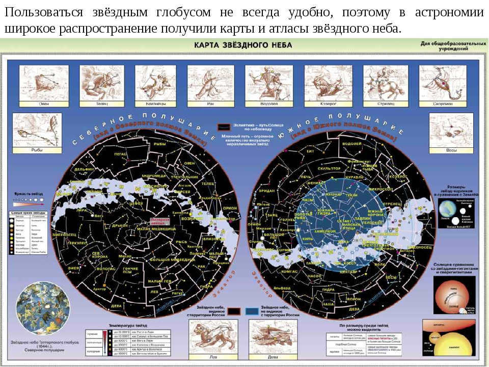
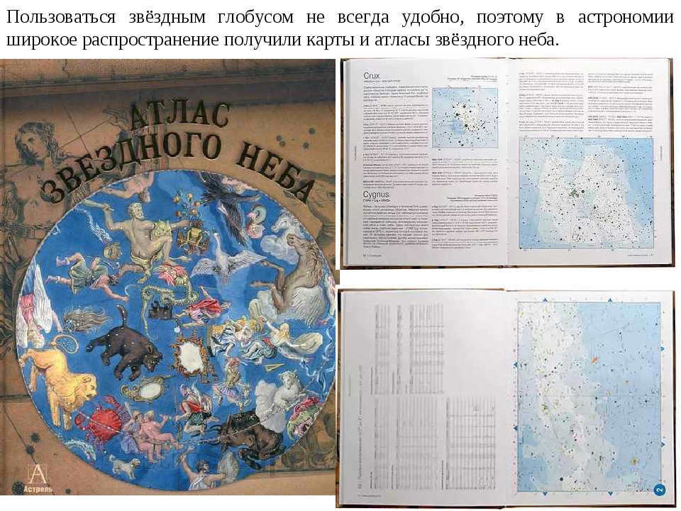
A star chart is an illustration of the night sky or a portion thereof, depicting the celestial objects (such as stars, planets, comets, etc.) positioned on it using a specific set of symbols. Similar to a traditional map, a star chart includes a coordinate grid based on the equatorial system of celestial coordinates. There are two main types of star charts: hand-drawn and photographic.
A collection of star charts that cover adjacent sections of the sky is known as a star atlas.
A star chart is used to identify astronomical objects in the night sky, cross-referencing them with entries in catalogs, and to locate objects based on their coordinates. Additionally, a star chart can assist in determining the approximate coordinates of celestial objects.
Maps depicting the celestial heavens, as we currently utilize them, were not introduced until the early 20th century. It was during this time that astronomers from all around the globe collectively agreed to divide the night sky into 88 distinct constellations. Prior to this development, various cultures had their own unique ways of dividing and identifying constellations.
The first individual to compile a star catalog was the ancient Greek astronomer Claudius Ptolemy, who lived during the 2nd century. Ptolemy’s catalog included 48 constellations and over one thousand stars.
During the Age of Discovery, when explorers were able to personally observe the Southern Hemisphere’s sky, star charts began to be regularly updated with new constellations. Additionally, older constellations often underwent name changes.
Because the Earth is constantly moving, the position of constellations in the sky changes depending on the time of year. Additionally, different hemispheres can see different constellations. This is important to consider when creating star maps.
In the present day, electronic star catalogs are predominantly used by professional astronomers. They use special graphic editors to create visual representations of various sections of the starry sky, complete with their current boundaries. Traditional book versions of star charts are primarily kept for educational purposes and are popular among amateur astronomers.
One of the standout professional atlases that have been published recently is the Millennium Star Atlas, which is comprised of three books with a very solid format. The maps in this atlas include all stars up to the 11th magnitude and, notably, for stars that astronomers know to have a fixed position, an arrow indicates their movement over the next thousand years.
By comparing the map of the same region of the sky (noting the gap in the Big Dipper) in this atlas with the map in the “New Uranometrics,” a prominent atlas from the mid-20th century, one can gain an understanding of how the appearance of the sky has changed over the past 150 years.
The celestial coordinates are numerical values that describe the position of a celestial object on the celestial sphere. Typically, spherical coordinate systems are used, which use two angular quantities to describe the position on a given sphere. Alternatively, Cartesian coordinate systems can be used if the distances to the celestial objects are known. However, instead of distance, the parallax of the celestial object is often specified. In high-precision measurements, the effects of the general theory of relativity must be taken into account. In such cases, the position of the celestial body is described relative to reference frames that consist of coordinate axes and a time scale (where time is considered the fourth coordinate of the celestial body).
- topocentric (the observer is located on the Earth’s surface),
geocentric (the observer is at the center of mass of the Earth),
barycentric (the observer is at the center of mass of the solar system)
objectocentric (the observer is at the center of mass of a planet, satellite, etc.).
In order to establish a coordinate system, it is necessary to specify its origin (typically the position of the observer) and the orientation of the axes. Subsequently, the primary plane of the system, which passes through the origin, is chosen. One of the spherical coordinates is then determined from the primary plane. The coordinate systems employed in astronomy are named after the primary plane of the system: horizontal, equatorial, ecliptic, and galactic.
2.1 The Horizontal Coordinate System
There are several celestial coordinate systems, including the horizontal (a), equatorial (b), ecliptic (c), and galactic (d) systems. In the horizontal coordinate system, the chosen direction is determined by the plumb line, and the main plane of the system is perpendicular to the plumb line. This system uses two coordinates to locate a celestial object: the zenith distance (z) and the azimuth (A) (Fig., a). Alternatively, the height (h) of the object above the horizon can be used instead of the zenith distance, with the relationship z+h=90°. When an object is above the horizon, its zenith distance ranges from 0° (when the object is directly overhead) to 90° (when the object is on the horizon). If the zenith distance is greater than 90° (h>0°), the object is below the horizon.
During this lesson, we will discuss the observable daily movement of the stars. We will review the fundamental concepts, lines, and planes of the celestial sphere. We will examine the coordinate system employed to denote the location of stars in the heavens. Additionally, we will acquaint ourselves with star charts and acquire the skill to ascertain the coordinates of stars from a map.
At the moment, you do not have the option to watch or share the video lesson with your students
If you want to watch this and other video lessons included in the package, you should add it to your personal account by buying it from the catalog.
Unlock amazing possibilities
Outline of the lesson “Celestial coordinates and star charts”
We have all witnessed the phenomenon of the Sun rising in the east multiple times. It emerges from beyond distant objects or irregularities on the Earth’s surface, gradually ascending above the horizon, and eventually reaching its highest point in the sky at midday. At this juncture, an observer in the northern hemisphere will perceive the Sun in the south, while someone in the southern hemisphere will see it in the north. After midday, the Sun gradually descends as it approaches the horizon and ultimately sets in the western part of the sky.
A similar celestial movement can be observed throughout the day with other celestial bodies such as the Moon, stars, and planets. In general, it appears as if the entire firmament rotates around a central axis, which we refer to as the axis of the world.
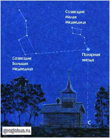
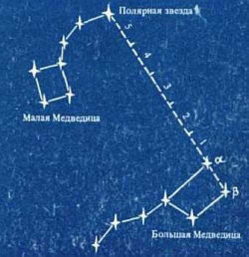
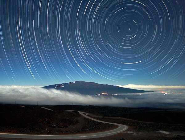
When gazing at the stars on a cloudless night in the northern sky, one can witness their graceful motion as they travel from east to west in circular patterns, revolving around Polaris (the alpha star of the Little Bear constellation). This specific point is referred to as the north pole of the Earth. In the southern hemisphere, one can locate the exact opposite point – the south pole of the Earth. It is important to note that the celestial sphere contains a significant circle known as the circle of declination, which traverses the poles of the Earth and the celestial luminary.
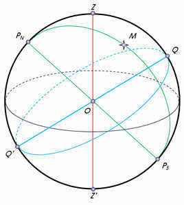
The celestial equator is the great circle that passes through the center of the celestial sphere and is perpendicular to the axis of the earth. It divides the celestial sphere into two parts: the Northern Hemisphere, which has its top at the North Pole of the earth, and the Southern Hemisphere, which has its top at the South Pole of the earth.
Furthermore, on the celestial sphere, the visible annual path of the Sun among the stars is traditionally indicated. This path is known as the ecliptic. It is inclined at an angle of 23 degrees 27 minutes to the celestial equator and intersects it at two points – the vernal equinox (around March 21) and the autumnal equinox (around September 23).
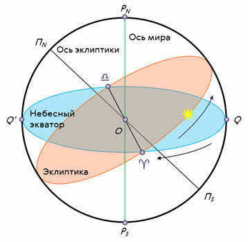
We have learned that the rotation of the celestial sphere is actually an apparent phenomenon caused by the Earth’s rotation on its axis from west to east.
The apparent movement of the celestial bodies due to the Earth’s rotation on its axis is known as diurnal motion, and the time it takes for the Earth to complete one rotation on its axis is called a day.
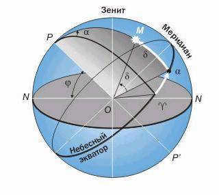
In one of our earlier lessons, we discussed how it appears to an observer on Earth that all the stars are situated on a spherical surface in the sky and are equidistant from it. This imaginary sphere with an arbitrary radius is known as the celestial sphere.
To denote the position of the stars in the sky, a coordinate system similar to the one used in geography is employed.
An equatorial coordinate system is the name given to such a system.
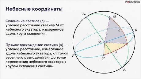
An equatorial coordinate system, which is similar to the one used in astronomy for indicating the position of celestial bodies in the sky, is quite convenient. In this coordinate system, the main circle of the celestial sphere is called the celestial equator, and the coordinates used are declination and right ascension.
Declination is the angular distance of a celestial body from the celestial equator, measured along the declination circle. It is represented by the small Greek letter δ and is analogous to geographic latitude. The only difference is that the declination of celestial bodies located north of the equator is considered positive, while those located south of the equator are considered negative. The starting point for measuring declination at the celestial equator is the vernal equinox.
The direct ascension, which is the second coordinate, represents the luminary’s position in the sky. In other words, it measures the angular distance along the celestial equator from the vernal equinox to the point where the celestial equator intersects with the luminary’s declination circle.
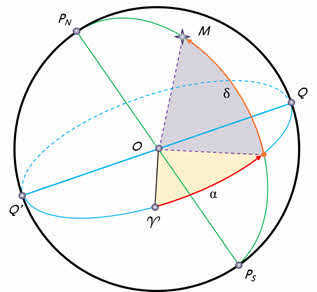
The inclination is indicated by the lowercase Greek letter α and is measured in the opposite direction of the daily rotation of the celestial sphere. It can range from 0 to 360 degrees or 0 to 24 hours. In astronomy, however, declination is typically expressed in hours rather than degrees. To put it simply, if we consider that 360 degrees are equivalent to 24 hours or 1440 minutes, then one degree would correspond to 4 minutes.
To understand why this is the case, let’s remember that in the horizontal system, the coordinates of a celestial body on the celestial sphere change over time. Therefore, these coordinates only have a specific value at a given moment in time.
In the equatorial system, the positions of stars are independent of the daily motion of the celestial sphere and change very slowly due to their distance from us. This makes the equatorial coordinate system ideal for star globes, maps, and catalogs.
Star maps are representations of the celestial sphere projected onto a flat surface, with objects plotted using a specific coordinate system.
A collection of star maps covering different sections of the sky, which can encompass the entire sky or a specific region, is known as a star atlas.
Specialized lists of stars, known as star catalogs, provide information about the coordinates of stars on the celestial sphere, their stellar magnitude, and other parameters. One notable star catalog is the Hubble Space Telescope Reference Catalog, also referred to as the reference star catalog-two, which includes data on over 945.5 million stars.
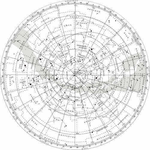
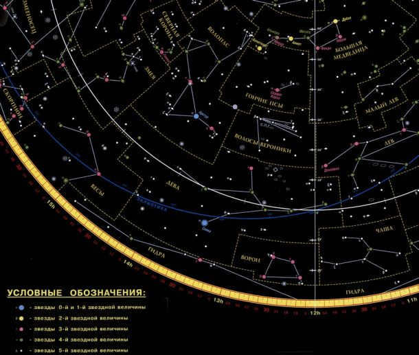
The map displays the grid of equatorial coordinates in a radial pattern emanating from the center, consisting of rays and concentric circles. Adjacent to each ray near the map’s edge, numbers are inscribed indicating the direct ascension, ranging from 0 to 23 hours.
The ray that serves as the starting point for measuring direct ascension passes through the vernal equinox, symbolized by the Aries symbol on the map. Declination is measured along these rays starting from the circle representing the celestial equator, which is labeled as zero degrees. The other circles on the map are also marked with digitized values representing the declination of objects located on those circles.
Stars on the map are depicted as circles with varying diameters, depending on their stellar magnitude. The stars that form recognizable constellation patterns are connected by solid lines, while the boundaries of the constellations are indicated by dotted lines.
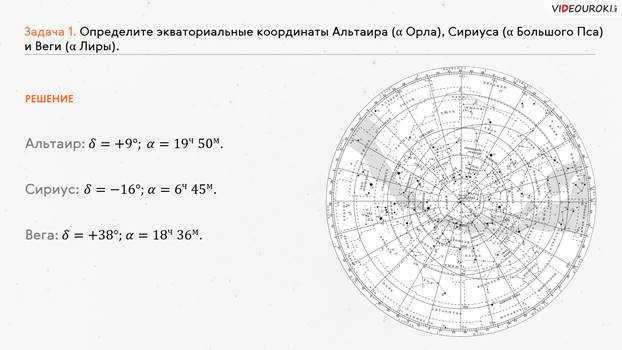
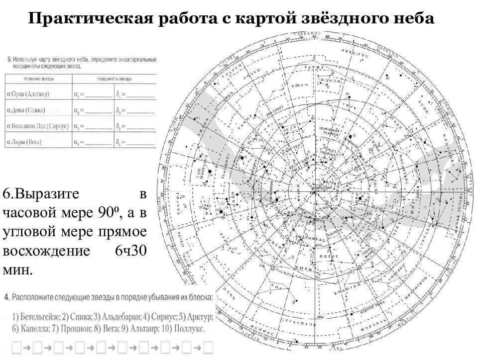
Now, let’s explore how to utilize the star map. To begin, we will determine the equatorial coordinates of Altair (the alpha star of Eagle), Sirius (the alpha star of Big Dog), and Vega (the alpha star of Lyra).
Let’s now tackle the reverse problem, which is to find a star based on its coordinates. So, suppose the star has a declination of +35 o and a right ascension of 1 h 6 m.
To find the answer to this question, we need to perform the same steps as before, but in reverse order. First, we locate the given right ascension on the star chart. Then, we draw a mental line (or use a ruler) connecting our point to the center of the star chart. Next, we locate the circle representing a declination of 30° and move about 5° upwards from it. As a result, we will find the star beta Andromeda.
It is worth mentioning that the star chart can serve multiple purposes, including locating the precise coordinates of stars and providing a visual representation of the night sky for a specific date. Additionally, it can also help determine the times at which stars, the sun, or planets rise and set.
Breakdown of the presentation, slide by slide:
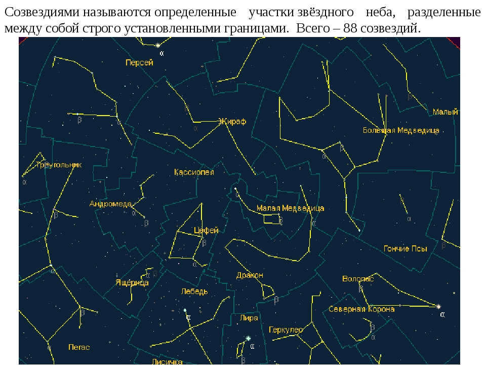
Constellations are specific regions of the celestial sky that are separated from each other by well-defined boundaries. In total, there are 88 constellations.
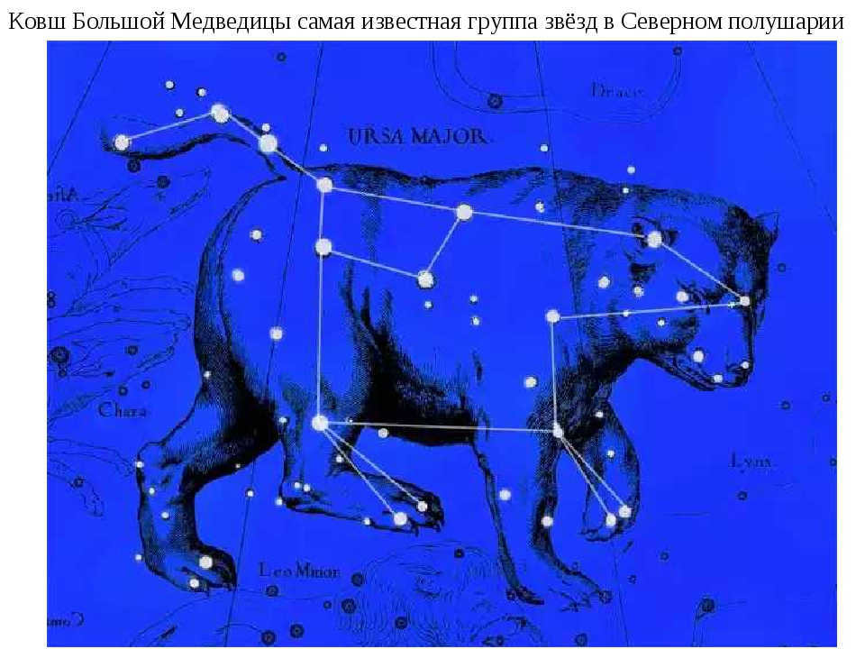
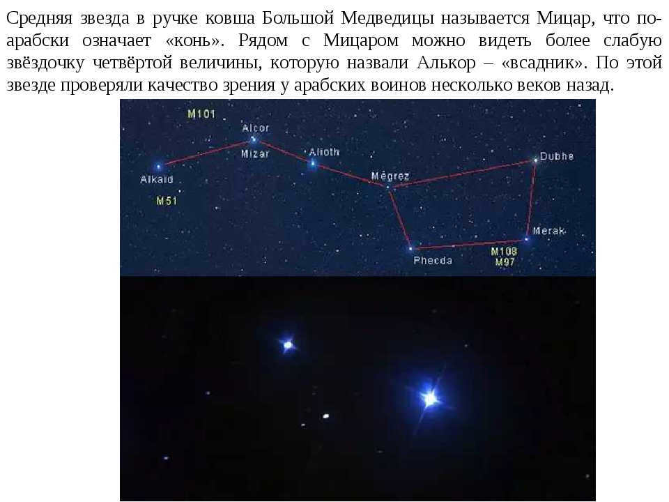
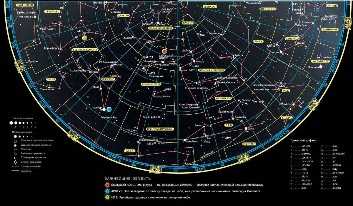
The handle of the Big Dipper is the most famous constellation in the Northern Hemisphere

In the 2nd century BC, Hipparchus classified all the stars that can be seen in the sky without a telescope into six different stellar magnitudes. The first magnitude stars, which are the brightest in the sky (there are fewer than 20 of them), can be easily seen with the naked eye. On the other hand, the sixth magnitude stars are barely visible without any optical aid.
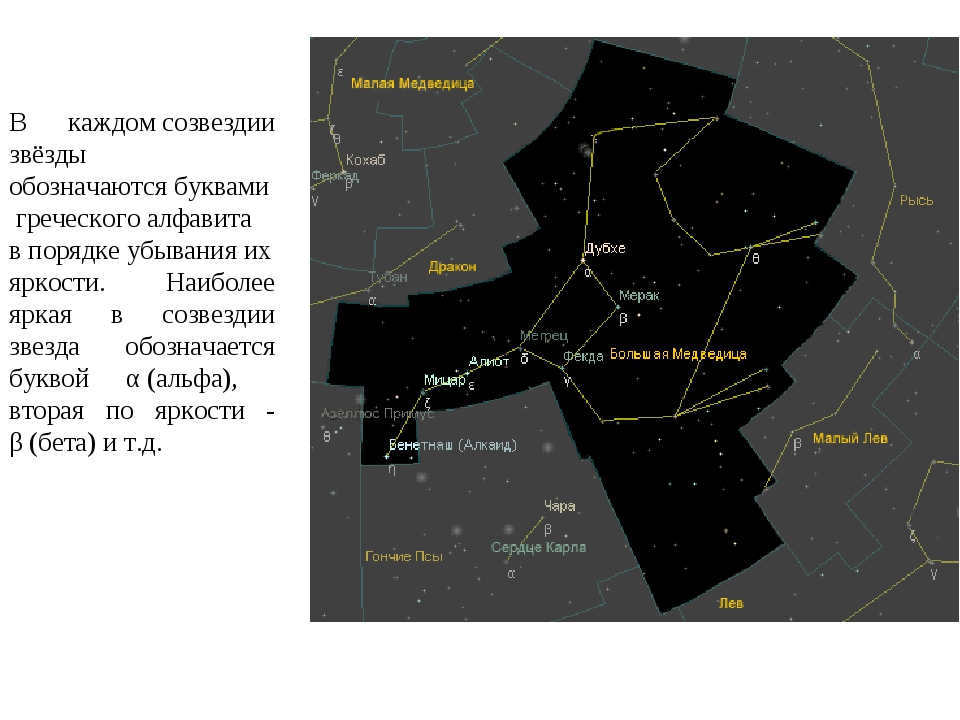
Each constellation has stars that are labeled with letters from the Greek alphabet, with the brightest star being designated as α (alpha), the second brightest as β (beta), and so on.
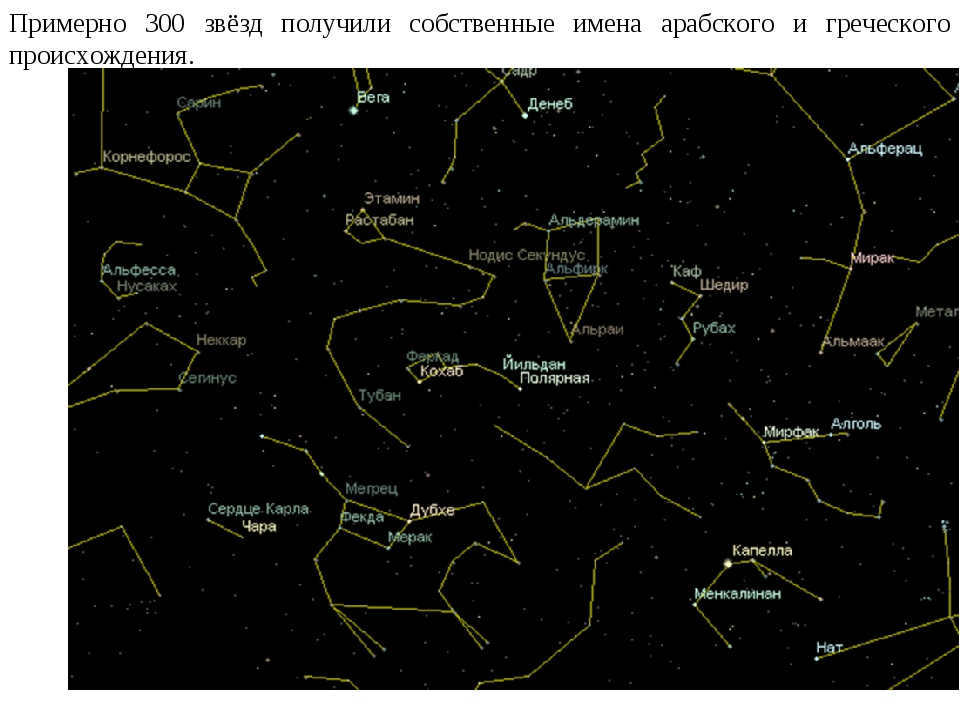
Around 300 stars have been granted names of Arabic and Greek origin.
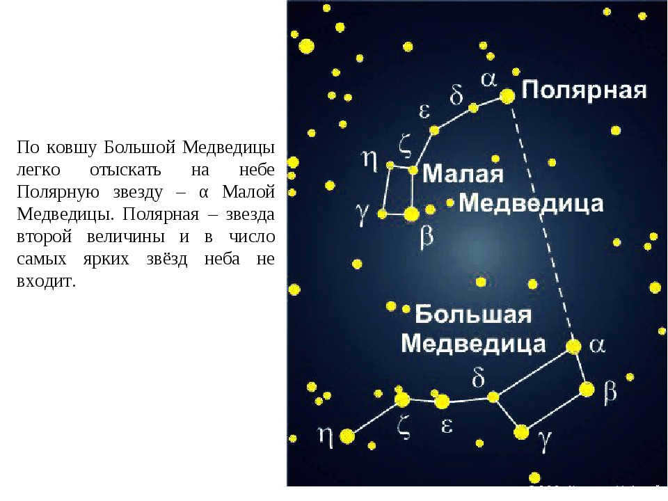
In the constellation of the Big Dipper, it is simple to locate Polaris, which is also known as α of the Little Dipper. Polaris is a star with a magnitude of two and is not one of the most brilliant stars in the celestial sphere.
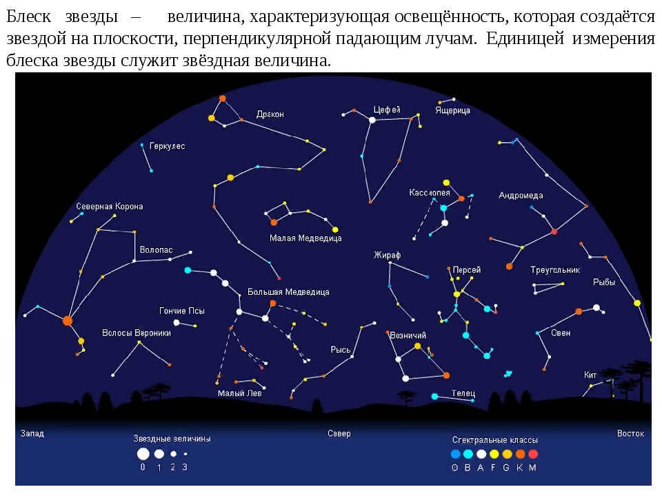
The brightness of a star is a value that represents the illumination created by the star on the plane perpendicular to the incident rays. The unit of measurement of the star’s brightness is the stellar magnitude.
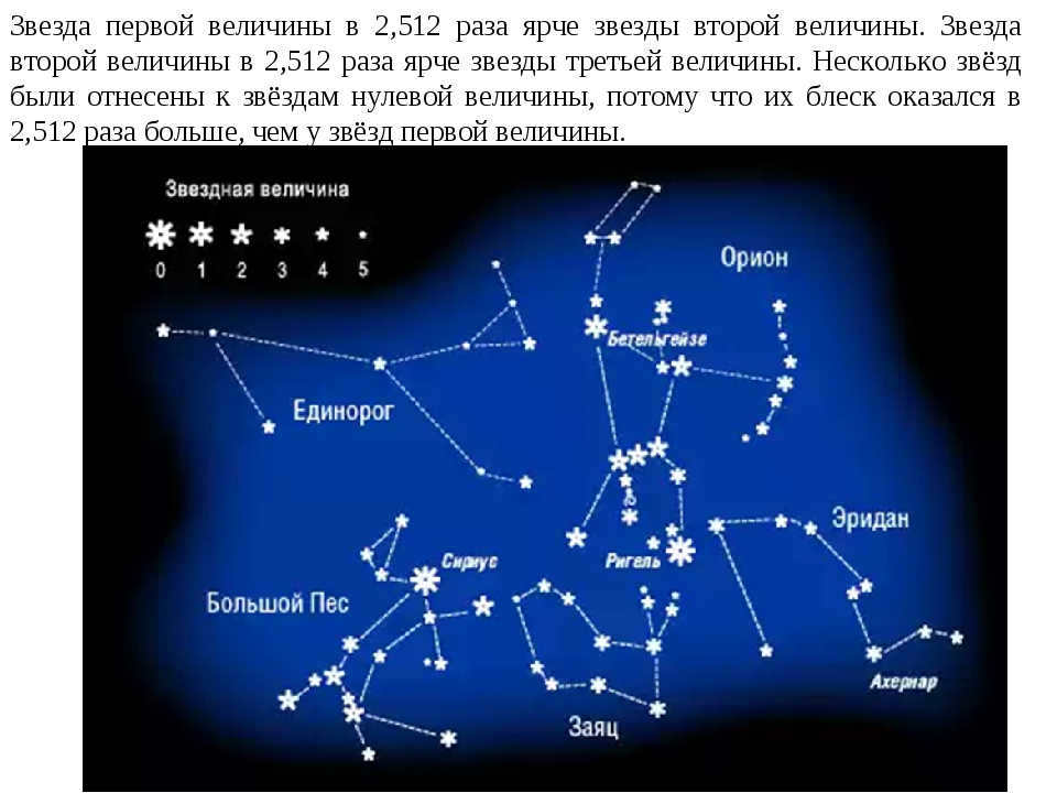
A star with a magnitude of one is 2.512 times brighter than a star with a magnitude of two. A star with a magnitude of two is 2.512 times brighter than a star with a magnitude of three. Several stars were designated as stars with a magnitude of zero because they were 2.512 times brighter than stars with a magnitude of one.


Task 1 Determine the ratio of brightness between a second magnitude star and a fourth magnitude star.

For Task 2, perform the identical calculation for stars with first and sixth magnitudes. Follow the instructions and round the resulting number to the nearest whole number.

ASTROLOGICAL POSITIONS AND STELLAR MAPS
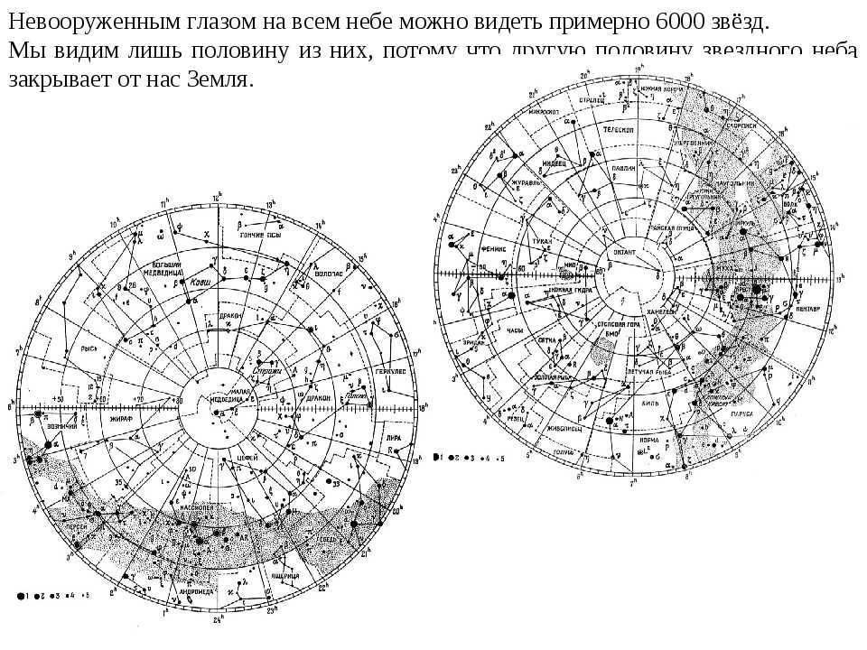
With the naked eye, it is possible to observe approximately 6,000 stars that are scattered across the entire expanse of the sky. However, due to the presence of our planet, we are only able to perceive around half of these stars, as the other half remains hidden from view.
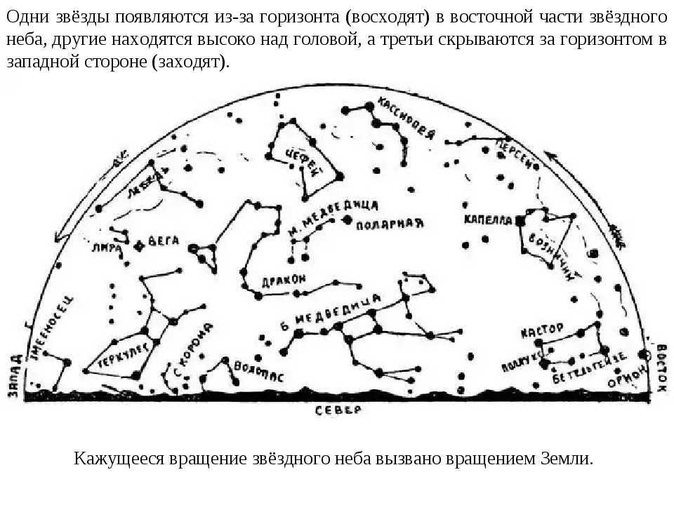
In the eastern part of the starry sky, certain stars emerge from the horizon, while others can be seen high overhead. Meanwhile, some stars remain hidden behind the western horizon. The rotation of the Earth is responsible for the apparent movement of the starry sky.
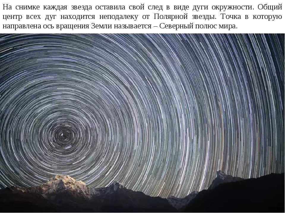
Each star in the image is marked by an arc of a circle. The central point where all the arcs intersect is located near Polaris. The North Pole of the Earth, which is the direction of the Earth’s rotation axis, is also depicted in the picture.
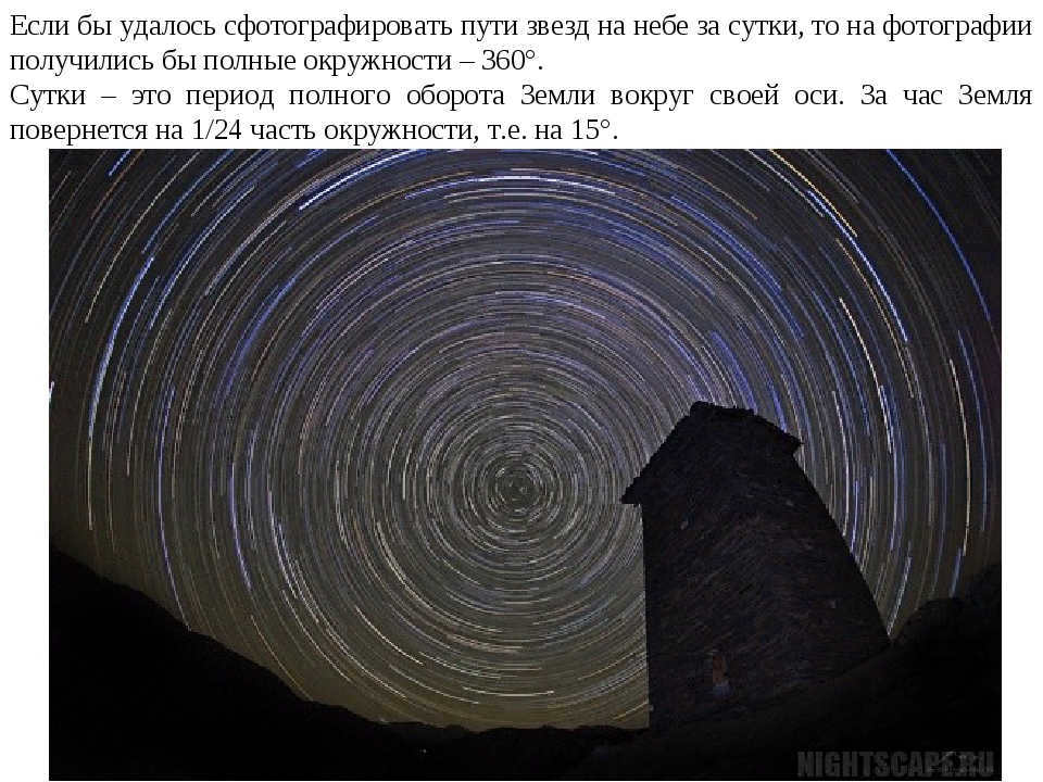
If it were feasible to capture the trajectories of celestial bodies in the atmosphere over the course of a single day, the resulting photograph would depict complete circles, totaling 360 degrees. A day signifies the duration required for the Earth to complete one full revolution around its axis. Within the span of an hour, the Earth completes 1/24th of a circular rotation, equivalent to 15 degrees.
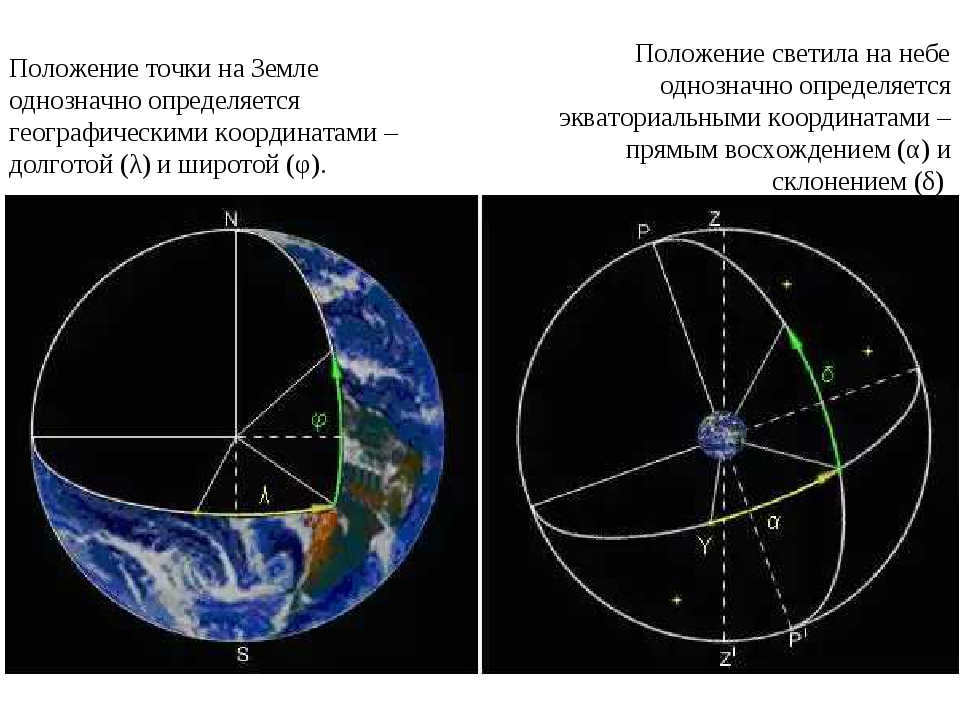
The geographical coordinates – longitude (λ) and latitude (φ) – provide a unique definition of a point’s position on Earth. Similarly, the celestial coordinates – right ascension (α) and declination (δ) – uniquely determine the position of a celestial body in the sky.
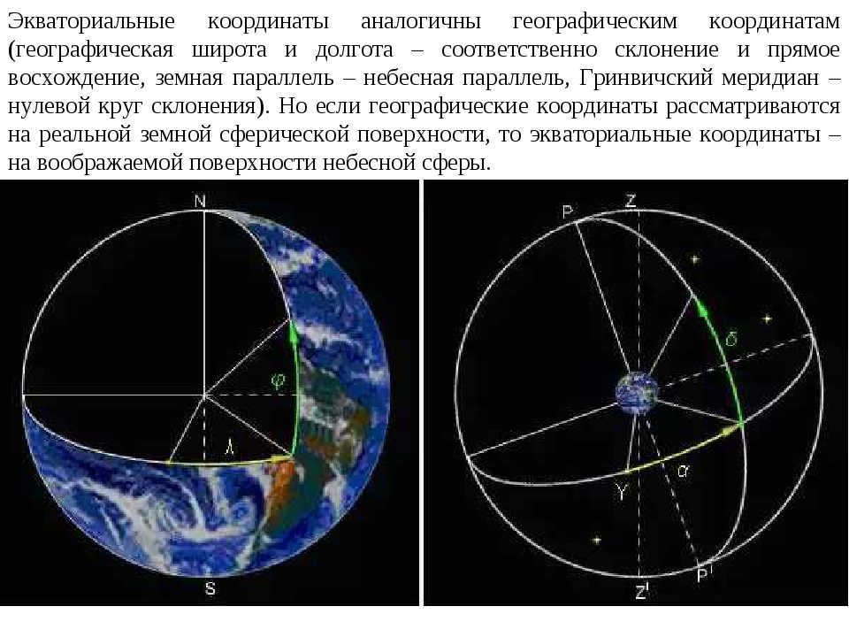
Equatorial coordinates are similar to geographic coordinates (geographic latitude and longitude – declination and right ascension respectively, Earth parallel – celestial parallel, Greenwich meridian – zero declination circle). However, while geographic coordinates are used to locate points on the actual spherical surface of the Earth, equatorial coordinates are used to locate points on the imaginary surface of the celestial sphere.
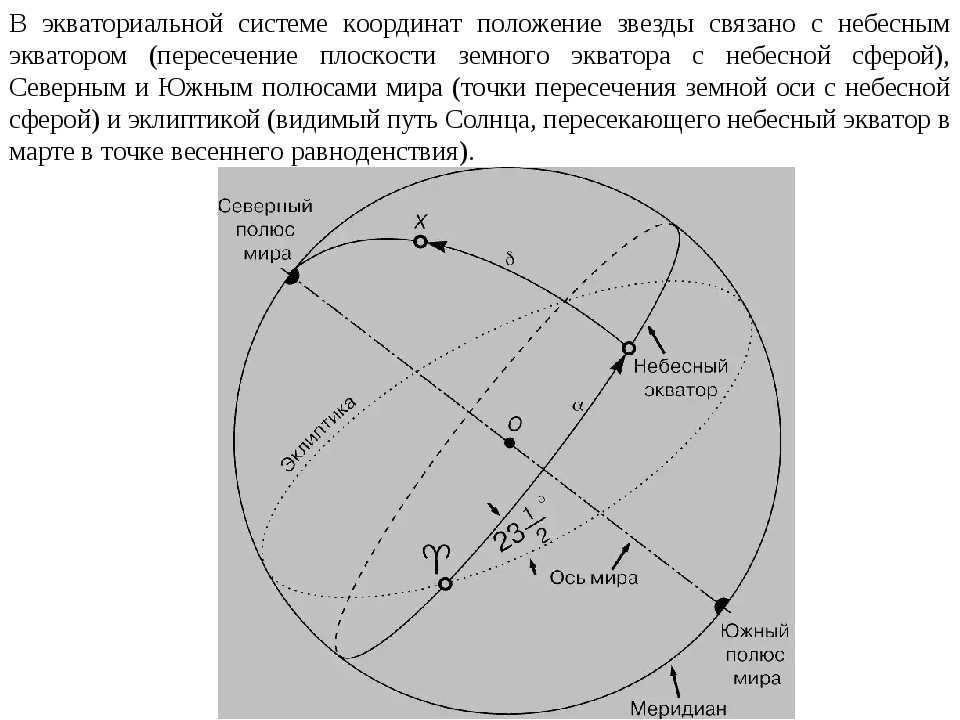
The celestial equator, which is the intersection of the Earth’s equatorial plane with the celestial sphere, plays a significant role in the equatorial coordinate system. This system defines the position of a star based on its relationship with the celestial equator, as well as the North and South Poles of the Earth, which are the points where the Earth’s axis intersects the celestial sphere. Additionally, the ecliptic, which is the apparent path of the Sun as it crosses the celestial equator during the vernal equinox in March, is also taken into account.
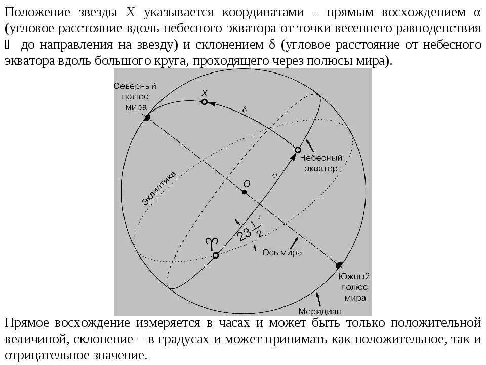
The coordinates of star X are represented by direct ascension α and declination δ. Direct ascension α is measured in hours and is always a positive value, while declination δ is measured in degrees and can be positive or negative. These coordinates indicate the position of star X in relation to the celestial equator and the vernal equinox ϓ.
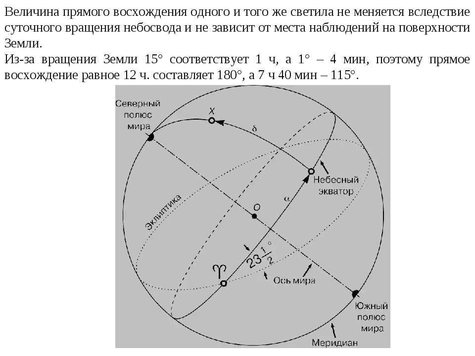
The direct ascension of the same luminary remains constant regardless of the daily rotation of the firmament and the location of observation on Earth’s surface. The Earth’s rotation means that 15° is equal to 1 hour, and 1° is equal to 4 minutes. Therefore, a direct ascension of 12 hours corresponds to 180°, and a direct ascension of 7 hours and 40 minutes corresponds to 115°.
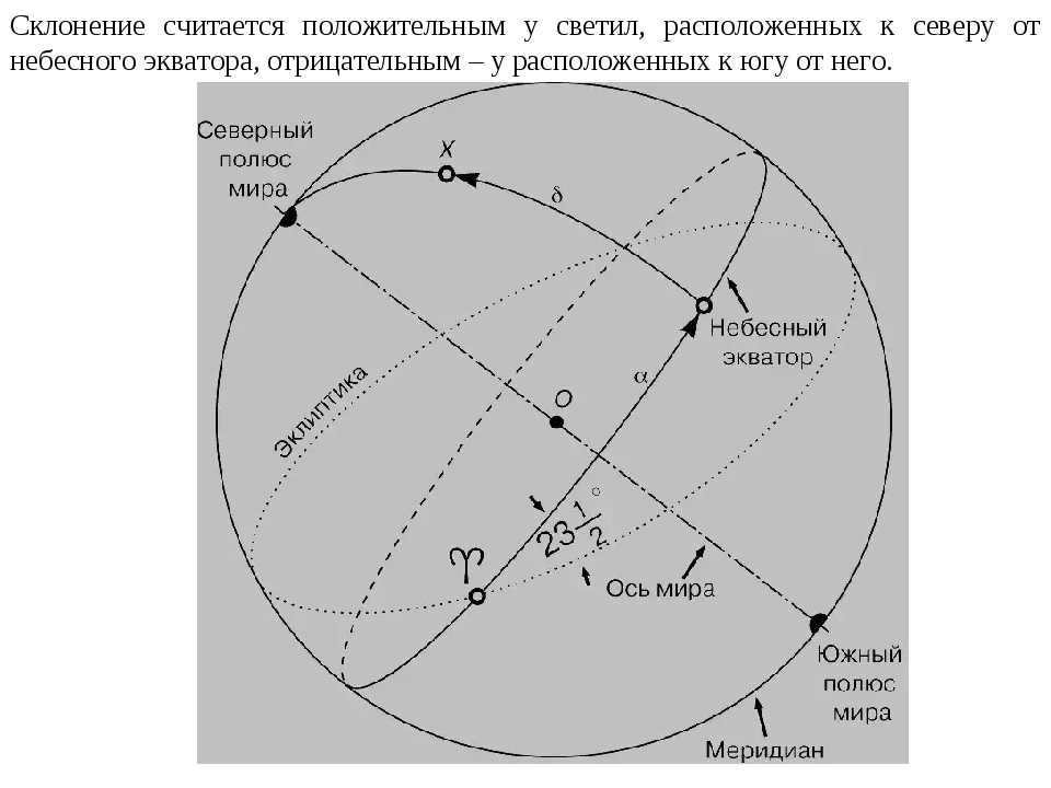
The positive value of declination is assigned to stars that are positioned in the northern part of the celestial equator, while the negative value is assigned to stars that are positioned in the southern part of it.
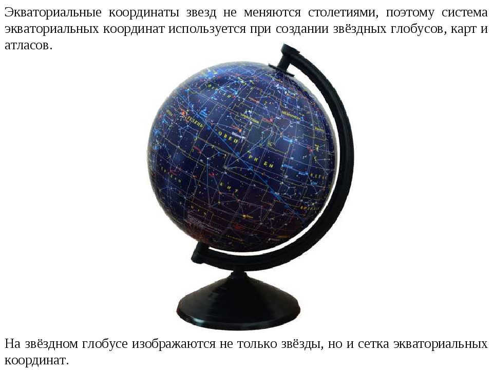
The system of equatorial coordinates remains unchanged as the equatorial coordinates of stars remain constant for centuries. This system is extensively used in creating star globes, maps, and atlases. A star globe not only displays the stars but also incorporates a grid of equatorial coordinates.
Maps and atlases of the celestial sphere are widely used in astronomy as an alternative to star globes, as they offer added convenience.
Due to the lack of convenience in using a star globe, the field of astronomy extensively relies on maps and atlases of the celestial sphere.

Movement of celestial objects. Celestial coordinates and charts of stars
Celestial coordinates and star charts
The unaided human eye has the capability to perceive approximately 6000 stars across the entirety of the celestial sphere. However, only half of these stars are visible to us due to the obscuring presence of the Earth. As a result of the Earth’s rotation, our view of the night sky continually changes. Some stars are just beginning to rise above the horizon in the eastern portion of the sky, while others reach their zenith directly overhead. Meanwhile, certain stars are already descending below the horizon in the western part of the sky. Consequently, it appears as though the entire starry expanse is rotating. It is now widely understood that this apparent rotation of the sky is simply an illusion caused by the Earth’s own rotation. The celestial dance resulting from the Earth’s daily revolution can be captured and preserved through the lens of a camera.
If it were possible to capture the trajectories of stars in the celestial sphere for an entire day, the resulting image would form complete circles – 360°. This is because a day represents one full rotation of the Earth on its axis. In the span of an hour, the Earth rotates by 1/24th of a circle, which is equivalent to 15°. Consequently, a star would trace an arc of 15° during this time, and half of that, 7.5°, in half an hour. To denote the positions of celestial objects in the sky, we employ a coordinate system similar to the one used in geography – the equatorial coordinate system. Just as geographic coordinates (latitude and longitude) are used to pinpoint locations on Earth, the equatorial coordinate system uses celestial longitude (f) to measure distance along the celestial equator from the prime (Greenwich) meridian, and celestial latitude (L) to measure distance along the meridians from the celestial equator to the poles of the Earth.

He organizes tours called “Nevsky Prospekt: From Home to Home” conducted by Rasner Vyacheslav Romanovich. Save e.
Hospitalized from the address Esenina St., 32, bldg. 2 (St. Petersburg, Vybo) on June 2, 2018 at 10:47 a.m.
Can we lend a hand to the little cat? Urgent repost! Friends, we all have a soft spot for kittens, don’t we? Assistance is needed max.
Assist liru-kotik! There are felines in pictures, there are felines on the streets. There’s a small category of kitten.
Group Search for Missing Children – Moscow Link to orientation on vk Community “Search for Missing De.
–Hyperlinks
–Labels
–Tunes
–Sign up via email
–Buddies
–Frequent readers
–Communities
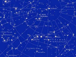
If you’ve ever looked up at the sky and wished you could distinguish one star from another, you’re not alone. Many people are eager to learn how to identify constellations, planets, and other celestial objects in the night sky.
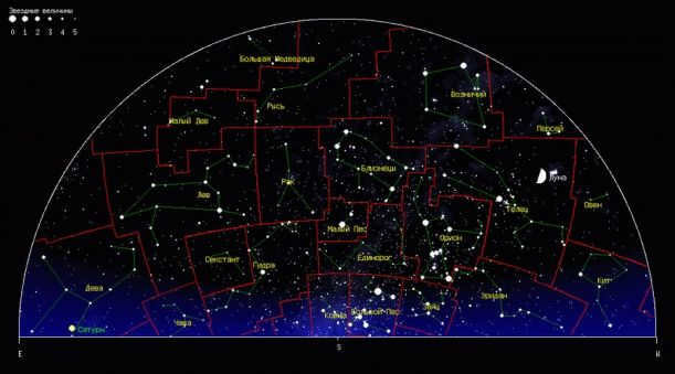
Fortunately, we can help you navigate through this vast array of “fireflies” in the sky. Don’t be intimidated, it’s not as difficult as it may seem. Plus, in the digital age, there are online star maps and virtual planetariums that can provide a realistic depiction of the sky at any given time and location.
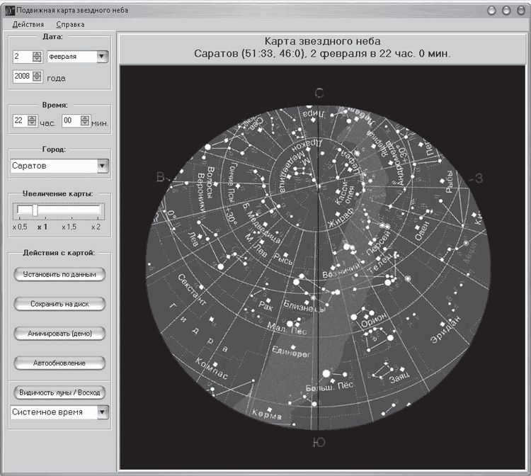
As an illustration, for the sake of convenience, there exists a website called Astronet http://www.astronet.ru/db/map/. We input the relevant information, such as the location and time of observation, as well as the map parameters, into the provided fields. After selecting “Go!”, the map will be generated and can be either printed or viewed on a computer monitor.
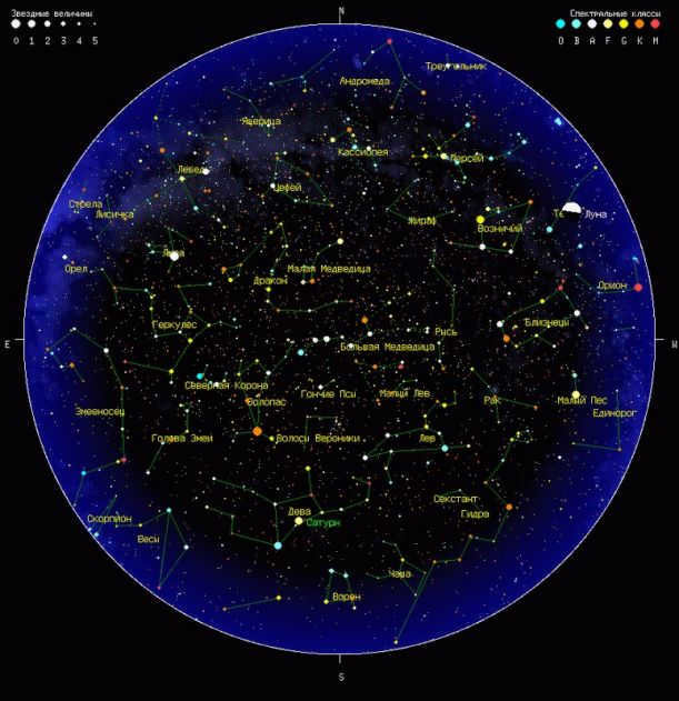
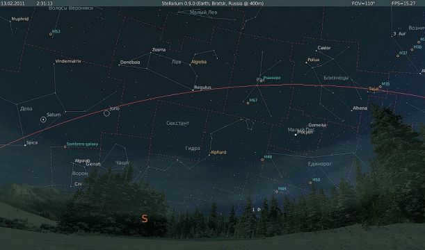
If you want to get a better understanding of the starry sky, we suggest using the free virtual planetarium Stellarium. It’s a great tool for getting acquainted with the night sky. In addition, make sure to enter the coordinates of your location in the program settings to see an accurate depiction of the sky from your position, rather than a generic view from the equator.
To begin withBefore commencing your work with the map, it is vital to get your bearings on the surrounding landscape and determine the locations of North (N), South (S), West (W), and East (E). You can utilize a regular compass or, if you know one of the directions, it will not be challenging to ascertain the other sides of the horizon.
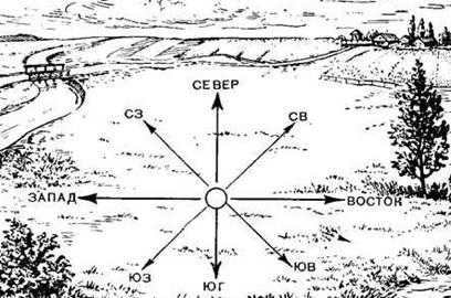
So, you find yourself in the middle. And in this scenario, if you happen to be looking towards the south, you will notice that the East is situated on your left side while the West is on your right side.
This may appear to be a complex concept, but it’s actually something that is taught in primary school. Furthermore, if you are already familiar with locating Polaris, then identifying the different directions of the horizon during nighttime will not pose any difficulty for you. It is worth noting that Polaris is always positioned above the northern part of the horizon in the Northern Hemisphere.
Secondly. Let’s revisit the map. The different directions on the map can be represented by Latin letters: N – north, S – south, E – east, W – west. Rotate the map so that the letter representing the direction you are facing is at the bottom. This will give you a star map that shows the sky from the horizon to the zenith (the point directly overhead on the celestial sphere). If you’re using a full “round” map of the entire sky, the zenith will be in the exact center of the circle.
Thirdly, in order to navigate the vast expanse of stars, people have historically divided them into distinct groups known as constellations. By mentally connecting the lines of bright stars, these groups were given names based on animals or mythological heroes, depending on the shape they resembled. Today, astronomers use these ancient constellation names as a way to designate the 88 sections of the sky. By referencing these constellations, astronomers can indicate the location of specific objects within them. For example, if it is stated that Mars is in the constellation of Cancer, this information can help locate the planet much like stating that Bratsk is in the Irkutsk region helps to locate the city.
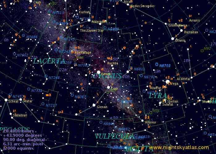
And in addition, there are over 50 brilliant stars that are named with Arabic, Greek, or Latin names. These names are indicated on maps, like Vega (located in the Lyra constellation). While there are many other stars with names, astronomers typically identify them using Greek letters or numbers from catalogs, such as θ of the Swan.
However, the number of stars visible in the city is much lower than what is shown on the map. This is mainly because the bright lights from street lamps create a glare that obscures the stars. Additionally, the human eye can only perceive the brightest stars in the night sky. Stellar magnitudes are used to measure the brightness of stars.
The magnitudes of the brightest stars are represented by negative numbers: the brightest star, Sirius, has a magnitude of -1.5m. On the other hand, dimmer stars have “positive” magnitudes. For example, Polaris has a magnitude of +2m. Amateur telescopes can detect stars with magnitudes up to +14m, while powerful observatories can detect stars with magnitudes up to +30m. The human eye, however, can only see stars with magnitudes up to +6m.
The brightness levels of stars will be shown on your sky maps. Typically, the more luminous the star, the larger the marker indicating it will be.
If we were able to see the stars during daylight, we would observe the Sun moving towards the east in relation to the distant stars over the course of the year. The ecliptic, which is the apparent path of the Sun against the backdrop of remote stars, is also commonly depicted on star globes and maps.
The path of the ecliptic can be seen traversing the sky through the 12 constellations, forming a band that is approximately 16 degrees wide. This band, known as the Zodiac, was named by ancient astrologers. What makes the Zodiac Belt particularly interesting is that the Moon and the planets, when visible in the sky, also tend to move along this path, passing through the twelve constellations.
So, now we are left with the less prominent grid lines on the star map, which indicate the hours and degrees. These lines represent celestial coordinates, similar to the geographic coordinates used to locate cities and objects on Earth. By knowing the right ascension (vertical grid lines, measured in hours and minutes) and declination (horizontal grid lines, measured in degrees), you can determine the position of a planet, star, or asteroid on the celestial sphere.
Additionally, it’s important to bear in mind that the perspective of the celestial sky changes as a result of the Earth’s daily rotation. With each passing night, the stars gradually shift towards the west in relation to the previous night. Consequently, a specific star will rise 4 minutes earlier from one evening to the next. Over the course of 30 days, this 4-minute discrepancy accumulates to a 2-hour difference. And within a span of 12 months, the difference would amount to a full 24 hours. Thus, after a year’s time, the view of the starry sky will return to its original position. The ever-changing appearance of the celestial sky throughout the year is attributed to the Earth’s orbit around the Sun. Every year, the Earth completes one full revolution around the Sun.
In the subsequent section, we will explore methods for locating specific objects in the celestial sky.
Wishing you clear skies and fruitful observations!
Quoted 5 times
Liked: 4 users
The Evolution of Studying Stars and the Creation of the First Star Charts
Have you ever had the opportunity to witness the breathtaking beauty of the night sky, far from the distractions of city lights? If so, you surely recall the mesmerizing twinkle of the stars against the backdrop of the dark, velvety sky. Throughout the vast majority of human history, this is precisely what the heavens looked like each evening. It is no wonder, then, that early civilizations organized these celestial bodies into constellations and integrated them into their mythologies. Unsurprisingly, the earliest astronomers were motivated by the (albeit false) belief that the stars and planets held a profound influence over human affairs.
This fascination gradually evolved into the field known as astronomy. Ancient Chinese bamboo books and Babylonian clay tablets contain documented observations of the celestial sphere using only the naked eye. The Greeks expanded upon these observations and constructed a conceptual model of the night sky, depicting the stars and planets as orbiting the Earth within crystal spheres.
A millennium and a half later, the Polish clergyman Nicolaus Copernicus revolutionized the prevailing belief by proposing that the Sun was the center of the solar system, with the Earth revolving around it. Galileo, through his observations with the telescope, forever altered our perception of the cosmos. The Earth lost its status as the focal point of the universe, becoming merely one celestial body among many. We discovered that our Moon is a realm of craters and mountains, and other planets possess their own satellites, known as “moons”. This revelation mirrored the miniature versions of the Solar System found in models.
Presently, we perceive the limited number of stars visible in the night sky as merely a small representation of the countless stars that exist within the vast Milky Way galaxy. Furthermore, we understand that our galaxy is just one of billions of galaxies scattered throughout the Universe. Even with this knowledge, modern observational astronomers continue to utilize star charts that bear striking resemblance to those employed in ancient times. These charts depict the stars set against the backdrop of a curved sky, with each individual star being designated to one of the 88 officially recognized constellations. The following series of maps, showcased on the subsequent eight pages, will aid you in locating the most brilliant stars and other celestial objects in the sky, allowing you to marvel at them in the same manner as our ancestors did thousands of years ago.
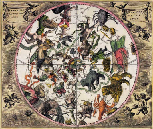
An illustration from the 18th century depicts the constellations of the Northern Hemisphere in the form of traditional figures that have been utilized since ancient times. While these figures may not be readily distinguishable from the stars themselves, they serve as a valuable point of reference in the night sky, and contemporary astronomers continue to utilize the constellations to identify and locate specific stars.
Understanding Star Charts
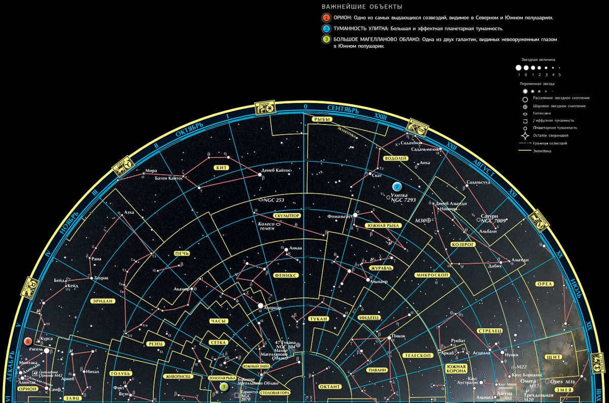
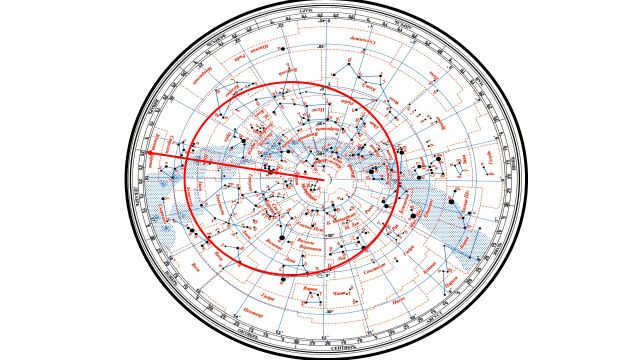
Star charts offer a unique perspective on the sky, as they depict how it appears when viewed from below rather than from above like traditional geographic maps. In this guide, we will explore four different star charts that showcase the Northern and Southern hemispheres. In the center of each chart, you will find either the North or South Pole. It is important to note that the celestial objects depicted on these charts are visible from both hemispheres.
To view a larger version of each chart, simply click on the image to open it in a new window.
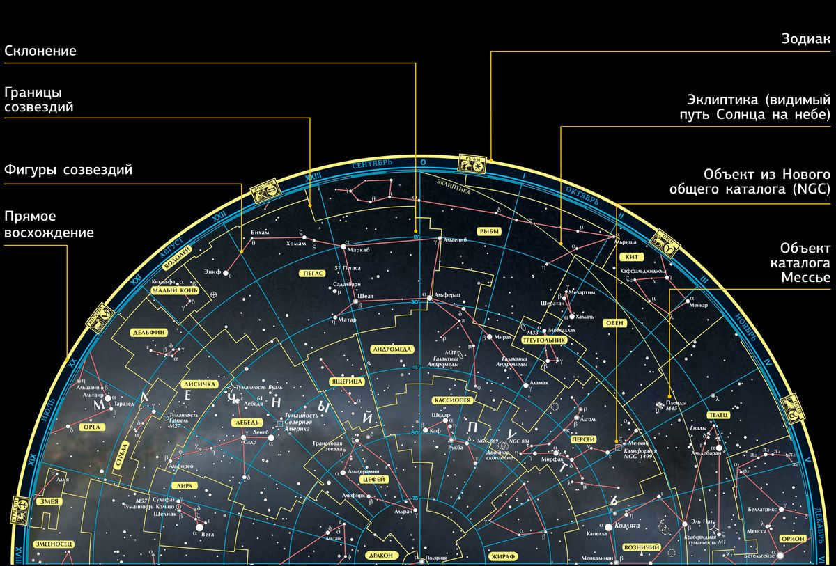
To accurately determine the position of celestial bodies, astronomers utilize celestial coordinates. In a manner similar to geographic longitude, direct ascent is measured in hours, minutes, and seconds and is denoted by Roman numerals along the perimeter. Declination, akin to geographic latitude, gauges an object’s distance from the celestial equator and is measured in degrees and minutes. On star charts, declination parallels are depicted as concentric circles in a shade of blue.
The Northern Hemisphere’s Stars and Constellations
To view a larger image, click on the picture which will open in a separate window
North sky in summer and autumn
This map shows the stars and constellations that can be seen high in the sky for an observer in the Northern Hemisphere from July to December. If you want to find a specific object on this map, like the bright star Vega, locate the object’s right ascension (18 hours 36 minutes) on the map’s edge, and then move towards the pole to a declination of +38 degrees.
Click on the image to open it in a new window and zoom in.
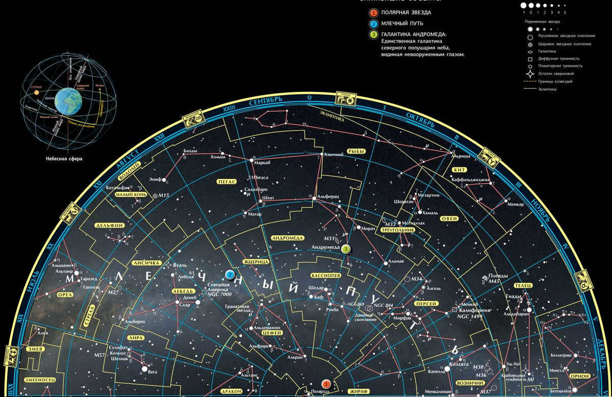
The Northern Hemisphere’s winter and spring skies
This map shows stars and constellations that can be seen high in the sky from January to June in the Northern Hemisphere. To locate a specific object, it is helpful to start with a familiar pattern like the Big Dipper and navigate from there. Remember that due to the Earth’s rotation, the stars and the Moon appear to move from east to west during the night.
Stars and constellations in the Southern Hemisphere
By clicking on the image, you can view it in a separate window and zoom in for a closer look.
The Southern Hemisphere: Summer and Autumn
This map displays the stars and constellations that can be seen in the Southern Hemisphere between July and December, when they are high enough in the sky for observation. The stars and constellations on the outer edges of this map can also be seen from most parts of the Northern Hemisphere. Unlike the Northern Hemisphere, the Southern Hemisphere lacks a prominent southern polar star, but it is home to some of the brightest stars and most stunning celestial formations.
To view a larger version of the image, click on it. It will open in a new window.
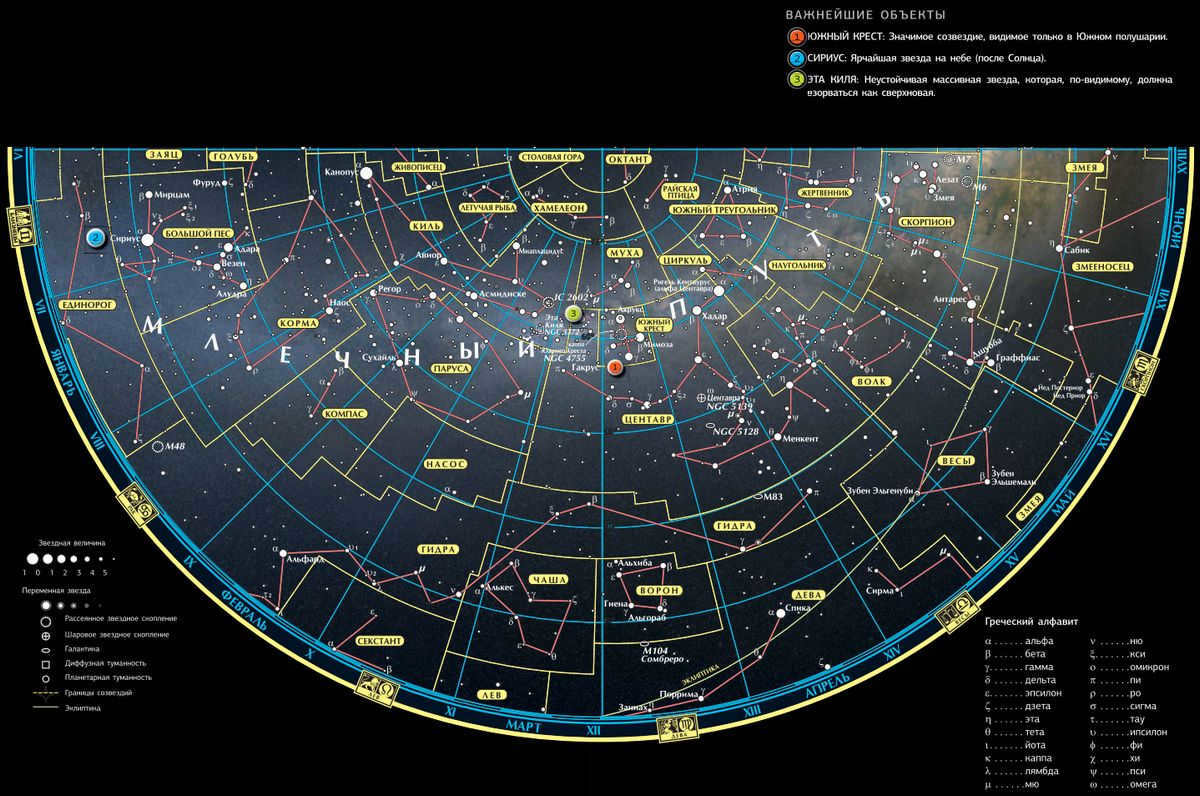
The Southern Hemisphere: Winter and Spring
This map displays the stars and constellations that can be observed at a high altitude in the Southern Hemisphere from January to June. Many of the star names, like Sirius (meaning “hot day”), have Greek origins. The presence of numerous Arabic names for stars, such as Algorab (meaning “raven”), reflects the significant contributions made by Arab astronomers in determining celestial positions.
How to determine geographical latitude using Polaris. Determining direction using clocks, the sun, and stars, and finding geographical longitude and latitude in field conditions.
Determining direction using a compass and finding the cardinal directions is relatively easy, but in the absence of a compass, you can use the sun, stars, plants, and other methods. In the northern hemisphere, the direction towards the north can be determined by standing with your back to the sun at noon. The shadow cast by your body will point north, acting like an arrow.
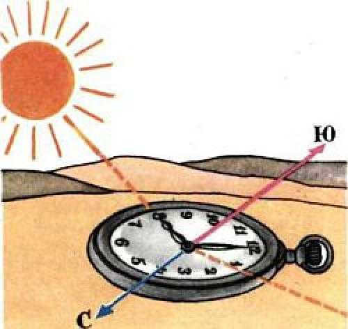
In the western hemisphere, the left hand side will correspond to the west direction, while the right hand side will correspond to the east direction. However, in the southern hemisphere, this is reversed, with the shadow pointing towards the south and the west and east directions switching places. To determine the north-south axis, place a watch on a flat surface and adjust it until the hour hand is facing the sun. Mentally draw a straight line through the center of the dial, starting from the number 1 position (equivalent to 13 hours). This line will act as the bisector of the angle formed by the hour hand and the line, and it will pass from north to south (as shown in the diagram). Before 12 o’clock noon, the south direction will be on the right side of the sun, while after twelve o’clock, it will be on the left side.
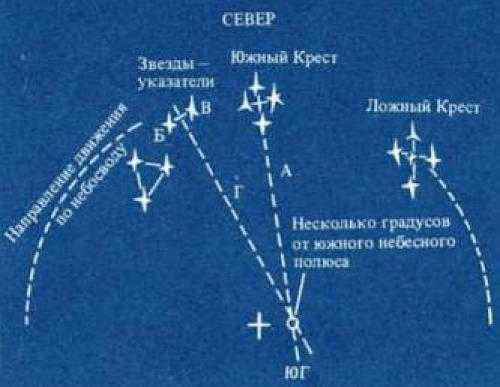
The position and alignment towards the southern direction is established by line A, which is conceptually drawn along the elongated axis of the Cross. To obtain a more precise determination of the celestial South Pole, utilize two stars known as pointers, positioned on the left side of the Southern Cross. By connecting them through an imaginary line B-B, passing through the center of the Cross, create a perpendicular line G, which extends until it intersects with line A. The point of intersection is located almost directly above the South Pole (refer to the diagram). It is important to differentiate between the authentic Southern Cross and the false cross. The stars composing the false cross are comparatively dimmer and are significantly more spread apart.
Orienteering using a compass
Techniques for navigating in the wilderness
It is also advantageous if an individual embarking on a hike or a journey possesses a compass. Particularly when it comes to navigation, it is essential in situations where selecting a reference point is impossible (such as in the tundra, desert, fog, or dense forest).
In order to ensure that the device is functioning properly and ready to assist, it is important to conduct a check. To do this at home, find a flat surface and place the compass on it, waiting for the pointer to stabilize. Then, take any metal object such as a needle, scissors, or knife, and bring it close to the compass. The arrow should start moving again. Once you remove the metal object, the arrow should freeze in the position it was in before. If this happens, it means that the instrument is in good working condition and can be used.
Additionally, it is crucial to remember an important rule when using a compass: avoid using it in close proximity to power lines, large metal objects, or natural anomalies. Why is this important? The reason is that the compass operates based on the alignment of magnetic arrows with the Earth’s magnetic field lines.
The Earth’s magnetic poles are indicated by the arrows. The listed objects above can cause the compass arrows to deviate.
To determine the directions of the world, place the compass flat and release the arrow from the clamp. After some time, the arrow will come to a stop and point towards the north with its highlighted end (the “north” end of the arrow may be colored, shorter, or shaped like an arrow). Once the north is determined, it becomes easy to locate the other directions: the opposite side will be the south, the right (from the north) will be the east, and the left will be the west.
After selecting a prominent object (such as a tree, mountain, or hill) along the path, the next step is to determine its azimuth. To do this, face the object and align the “0” mark on the scale with the northern end of the arrow. The numerical value on the compass scale pointing towards the object will be its azimuth, which can also be used for the return journey.
It is important to remember that azimuths are always measured clockwise, no exceptions!
The azimuth for north is either 0° or 360°.
Take note of the numerical value that is directly opposite the initial value and commit it to memory. This will serve as the azimuth for the forward direction.
This figure will be used to verify the trajectory of the path.
By following the compass, an individual is certain to arrive back at the same spot where their journey began.
Navigation using celestial bodies
Observable movement of the stars
All celestial objects in the sky are in a constant state of motion, never remaining stationary. Although it may appear that the stars are motionless when observing them, this is simply an illusion. In comparison to the moon or the sun, the stars’ movement is hardly noticeable. This is due to the fact that their speed is relatively slow in relation to their immense distance from Earth. The human eye is unable to detect the subtle movements of stars, even after years of observation from the same vantage point. However, with the aid of a telescope, one can observe the slight shifts in a star’s position. It is worth noting that the Sun and Bernard’s star, which cannot be seen with the naked eye, exhibit a faster motion. Despite the need for a telescope to observe a star, its angular velocity is greater than that of other stars.
The motion of heavenly bodies is both daily and yearly. Throughout the daily movement, stars alter their position in relation to the different sides of the horizon. The stars carry out their observable daily motion along with the celestial sphere. This observable motion is directly connected to the Earth’s rotation on its axis. By observing the Sun, it is evident how it rises in the east during the early morning and sets in the west in the evening. Over the course of a year, it traverses through 12 zodiacal constellations, spending approximately a month in each.
What can be seen in the city sky?
The city sky offers a variety of observable objects, including the moon, planets, the brightest stars, and constellations. These celestial wonders can be observed with the naked eye, binoculars, or a small telescope. With the help of binoculars, one can even see the brightest star clusters and variable stars. And for those who have a telescope, there are even more exciting things to observe, such as double and multiple stars, faint variable stars, planets, and the detailed surface of the Moon.
However, it is important to note that the urban sky may limit the visibility of certain objects. Only the brightest nebulae and galaxies can be seen in a telescope within the city limits. To truly appreciate the beauty of deep space objects, it is advisable to venture far away from the city lights. Exploring the outskirts of the city, such as the forest, mountains, or steppe, will provide a more optimal stargazing experience.
An application has been developed to track the positions of stars, planets, satellites, and constellations on a space map. By simply pointing your phone at the sky, you can now see the real-time location of celestial bodies (provided your device has a built-in compass sensor).
The application also allows for easy searching by name. Simply enter the desired object and the program will find its location and provide information about it. Please note that the free version of the app may include advertisements.
- The star atlas can be viewed during both day and night time.
- The application also provides information about moon phases, the exact positions of stars, and sunrise/sunset times.
- Users can track various objects such as stars, planets, asteroids, comets, meteor streams, constellations, and satellites.
Methods for Determining Latitude and Longitude. Accurate Determination of Geographic Coordinates.
To determine the longitude and latitude of a point more accurately than 0.5 degrees, you first need to determine the scale of the map you are working with. Typically, a scale bar can be found in one of the corners of the map, which indicates the relationship between distances on the map and distances in geographic coordinates and kilometers on the ground.
Once you have found the scale bar, you can use a simple ruler with millimeter divisions to measure the distance on the scale bar. For example, let’s say that 50 mm corresponds to 1 degree of latitude and 40 mm corresponds to 1 degree of longitude.
Next, we position the ruler in alignment with the longitude lines displayed on the map and calculate the distance between the specified point and one of the nearby parallels. For instance, the distance to the 11° parallel measures 35 mm. By using a straightforward ratio, we determine that this distance corresponds to 0.3° from parallel 10°. Consequently, the latitude of the point in question is +10.3° (the positive symbol indicates a northern latitude).
Popular topics of discussion
- Bryansk City Bryansk serves as the administrative center of the region with the same name, situated in the European part of Russia. It is one of the oldest cities, established as a Slavic fortress in 985. Originally, the town was known as Debryansk.
- Idiomatic expressions In order to make our speech more diverse, sophisticated, expressive, and in line with the current norms of the Russian language, it is crucial to expand our own vocabulary and strive for constant improvement.
- Exploring museums When visiting different cities, it is always exciting to explore their beautiful attractions. One such fascinating tourist destination is Almetyevsk, rightfully known as the capital of the oil region.
Which planets can be observed from Earth?
It is only natural that if we are able to see stars that are so far away, then we should also be able to see objects within our own solar system. So, which planets from our Solar System are visible from Earth?
With the naked eye, we can easily spot 5 planets. However, locating planets in the night sky can be challenging as they are not stationary and constantly move in relation to both the Earth and each other. This is why it is most convenient to use an actual map.
The main characteristic that distinguishes planets from stars is that they do not twinkle. Additionally, because they are relatively close to Earth, they appear as disk-shaped objects in the sky rather than mere dots like stars. However, this is not always easily discernible to the naked eye.
Some planets undergo rapid changes in their celestial position. Take Mars and Mercury, for instance. However, Mars is easily identifiable due to its distinct coloring. It stands out as the most crimson dot in the entire sky. It can even be spotted in the dead of night. For instance, during the summer of 2020, Mars could be seen in the constellation of Pisces closer to midnight. On the other hand, in August 2021, Mars was visible during the daytime in the Northern Hemisphere and remained hidden at night.
Venus, on the other hand, is quite conspicuous from our vantage point on Earth. Firstly, it shines the brightest among all the celestial bodies, owing to its proximity to us, which makes it appear larger. Secondly, it is typically one of the first to emerge or the last to vanish from the sky. It’s like a nurturing mother figure. It rises before everyone else and sets after everyone else.
Venus in the eastern sky at dawn in 2020.
If you want to catch a glimpse of Venus, you’ll need to keep tabs on her current cycle. In 2020, I spotted her every morning in the eastern sky. However, in 2021, she’s shifted to the western sky and can be seen at sunset during the summer months. Once nightfall hits, she dips below the horizon and becomes invisible.
If you’re lucky, you might also be able to observe Mercury, but you’ll have to consult maps to determine its whereabouts.

Take a look at the vibrant speck in the heavens, a slightly warmer hue than the surrounding celestial bodies? That luminous object is not a mere star. It happens to be our magnificent Jupiter.
That’s how brilliantly it shines! In the year 2021, it could be observed in the southeastern portion of the sky. This photograph was captured during the full moon of August.
Jupiter can be found on the left side, while Saturn is situated on the right side of the Moon.
Saturn is visible in close proximity to Jupiter. If you peer through a telescope, you can even catch a glimpse of its majestic rings. However, to the naked eye, Saturn would appear as a diminutive disk emanating a pale glow, a cooler shade when compared to its colossal neighbor Jupiter.
The remaining planets are scarcely visible from our vantage point on Earth.
An astronomical map is a visual representation of the night sky or a section of it, displaying various celestial objects such as stars, planets, and comets using a system of standardized symbols. Similar to a geographical map, an astronomical chart includes a coordinate grid based on the equatorial system of celestial coordinates. There are two main types of astronomical charts: hand-drawn and photographic charts.
A collection of adjacent celestial maps is known as an astronomical atlas.
An astronomical map is utilized to identify celestial objects by comparing them to cataloged objects, as well as to locate specific objects based on their coordinates. Additionally, it can be used to estimate the approximate coordinates of celestial objects.
Only in the early XX century did maps of the celestial sky, as we now use them, come into existence, when astronomers worldwide decided to divide the starry sky into 88 constellations. Before that, various peoples, at different times, divided the sky into constellations in their own unique ways.
The ancient Greek astronomer Claudius Ptolemy (2nd century) was the first to create a star catalog. His catalog included 48 constellations and over a thousand stars.
Since the beginning of the Age of Discovery, when seafarers were able to witness the Southern Hemisphere’s sky firsthand, star charts have been continuously updated with new constellations, and old constellations often received alternative names.
Because of the Earth’s constant movement, the arrangement of constellations in the sky varies depending on the season. Additionally, different constellations can be seen in different parts of the world. This important information must be taken into consideration when creating celestial maps.
In today’s world, professional astronomers primarily rely on electronic star catalogs. Utilizing special graphic editing software, they can display visual representations of various sections of the night sky, complete with modern boundaries. Traditional star charts in book form are mainly kept for educational use and are also popular among amateur stargazers.
One of the standout professional atlases released in recent years is the Millennium Star Atlas, which is comprised of three books in a very sturdy format. The maps in this atlas include all stars up to the 11th magnitude and, notably, for stars that astronomers know have a fixed position, an arrow indicates their movement over the next thousand years.
By comparing the maps of the same sky region (take note of the gap in the Big Dipper) in this atlas and the “New Uranometria”, the primary atlas from the mid-20th century, you can gain an understanding of how its appearance has changed over the past one hundred and fifty years.
Position of the star in relation to the cardinal directions
Polaris indicates the direction of geographic north, although with a small deviation. When observing Polaris, a person is oriented towards the north, with the south behind them, the east on their right, and the west on their left. However, this method is not effective near the north pole, where Polaris is directly overhead. In such situations, alternative methods for orientation should be utilized, which are thoroughly explained in the accompanying material…
The nearest point to the center of the circles is Polaris. In this direction lies the north.
That is why the technique of orienteering using Polaris is considered one of the most precise – it is more accurate than orienteering with a compass. It is not uncommon to use Polaris to determine the error in compass readings.
Star Maps: Coordinate Lines
To aid in navigation, certain star charts include coordinate lines that enable you to more precisely locate a faint or interesting celestial object. These coordinate lines indicate the positions of right ascension (RA) and declination (dec) – which are akin to longitude and latitude on Earth – on the star chart. RA and dec (also represented by the Greek letter δ) are coordinates that denote the position of a star (or galaxy) in relation to two reference points in the sky:
The celestial equator (a line in the sky directly above Earth’s equator)
The enigmatically named First Point of Aries, situated in the constellation of Pisces.
Declination is a measurement that indicates the angular distance between a star and the celestial equator. This measurement, expressed in degrees, is similar to how latitude measures the distance from Earth’s equator. For example, when astronomers state that Canopus has a declination of -52°41 ‘, it means that the star is located many degrees south of the celestial equator. In the southern hemisphere, all stars have a negative declination value.
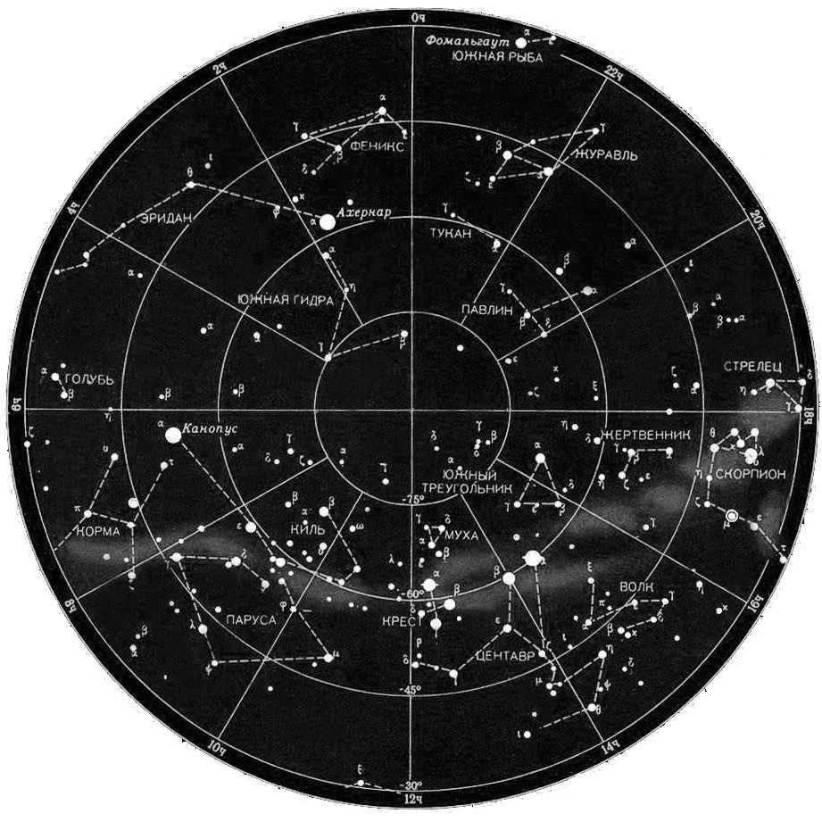
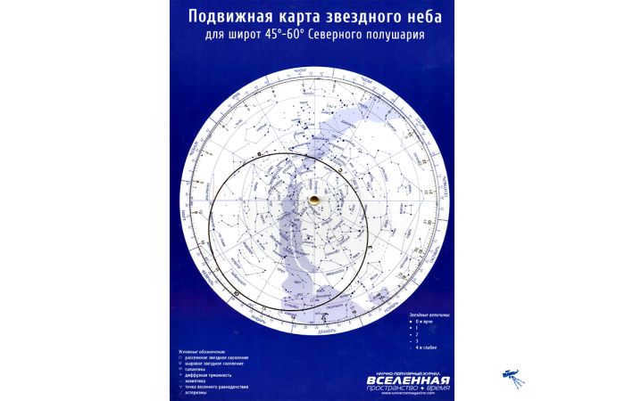
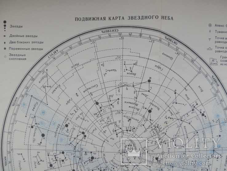
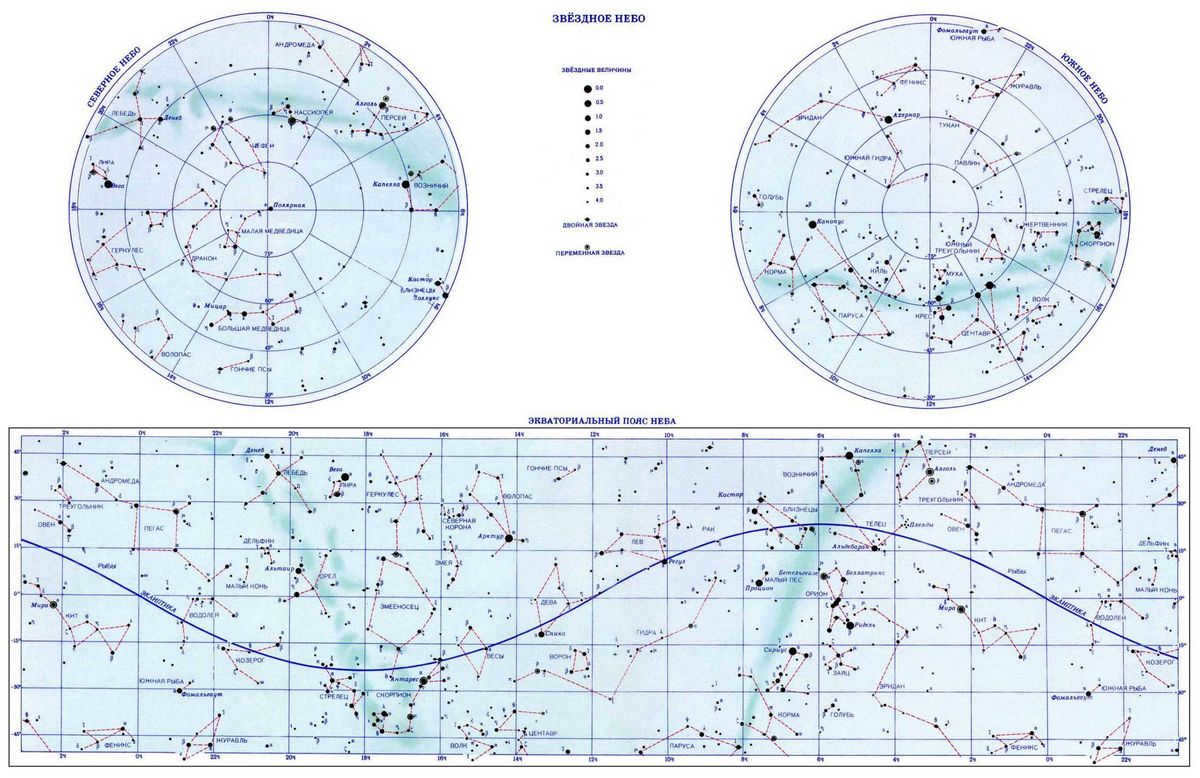
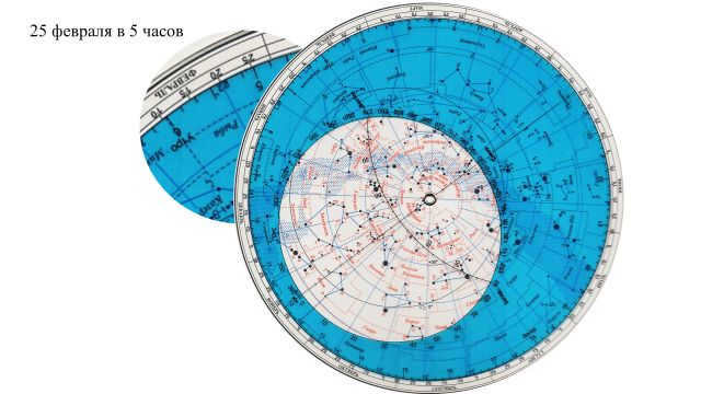
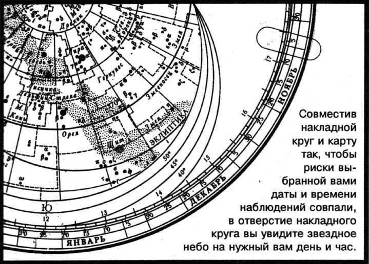
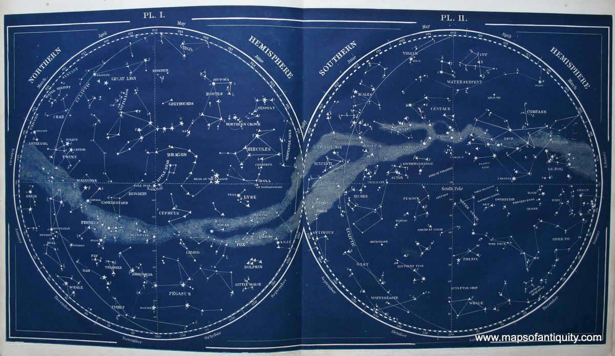
When someone mentions that Canopus has an RA of 06×24 meters, it means that its right ascension coordinate is slightly more than a quarter of the way around the sky (6 h – one quarter of 24 h) from the First Point of Aries. Right ascension is always measured east of the First Point of Aries.
Summary
The bright stars in the constellations are located at varying distances from the Sun.
Stars that appear close together on the celestial sphere can actually be very far apart in three-dimensional space. Therefore, a constellation can contain both stars that are very close to the Earth and stars that are very far away, with no connection between them.


